Local Weather Station (N5ZKK)
Observation Time:
Jul 22 2026 15:40 CDT
Temperature:
104°F
Humidity:
38%
Barometric Pressure:
inHg
Wind Vector:
7° @ 4 mph
Peak Wind Gust:
6 mph
Precipitation (1-Hour):
0.00 in
Precipitation (24-Hour):
0.00 in

GOES Regional Radar Arrays
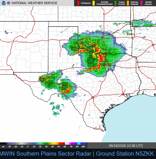
Southern Plains Sector (Texas Local)
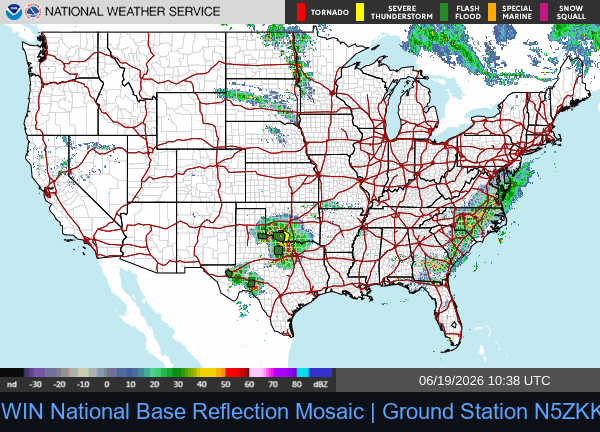
National Radar Mosaic
Active EAS Convective Bulletins (3-Hour Window)
WGUS61 KAKQ 221748
FFAAKQ
Flood Watch
National Weather Service Wakefield VA
148 PM EDT Wed Jul 22 2026
VAZ048-060>062-065>069-076>090-092-099-100-509>520-522>525-528-
230200-
/O.CON.KAKQ.FA.A.0005.000000T0000Z-260723T0400Z/
/00000.0.ER.000000T0000Z.000000T0000Z.000000T0000Z.OO/
Fluvanna-Prince Edward-Cumberland-Goochland-Mecklenburg-Lunenburg-
Nottoway-Amelia-Powhatan-Richmond-Northumberland-Lancaster-
Brunswick-Dinwiddie-Prince George (including Hopewell and
Petersburg)-Charles City-New Kent-Gloucester-Middlesex-Mathews-
Greensville-Sussex-Surry-James City-Southampton-Accomack-
Northampton-Western Louisa-Eastern Louisa-Western Hanover-Eastern
Hanover-Western Chesterfield-Eastern Chesterfield (Including Col.
Heights)-Western Henrico (Including the City of Richmond)-Eastern
Henrico-Western King William-Eastern King William-Western King
and Queen-Eastern King and Queen-Eastern Essex-York-Newport News-
Hampton/Poquoson-Isle of Wight-
148 PM EDT Wed Jul 22 2026
...FLOOD WATCH REMAINS IN EFFECT UNTIL MIDNIGHT EDT TONIGHT...
* WHAT...Flash flooding caused by excessive rainfall continues to be
possible.
* WHERE...Portions of central, east central, eastern, south central,
and southeast Virginia, including the following areas, in central
Virginia, Amelia, Cumberland, Eastern Chesterfield (Including Col.
Heights), Eastern Hanover, Eastern Henrico, Eastern Louisa,
Fluvanna, Goochland, Powhatan, Prince Edward, Western
Chesterfield, Western Hanover, Western Henrico (Including the City
of Richmond) and Western Louisa. In east central Virginia, Charles
City, Eastern Essex, Eastern King William, Eastern King and Queen,
New Kent, Richmond, Western King William and Western King and
Queen. In eastern Virginia, Gloucester, Lancaster, Mathews,
Middlesex, Northampton and Northumberland. In south central
Virginia, Brunswick, Dinwiddie, Lunenburg, Mecklenburg, Nottoway
and Prince George (including Hopewell and Petersburg). In
southeast Virginia, Accomack, Greensville, Hampton/Poquoson, Isle
of Wight, James City, Newport News, Southampton, Surry, Sussex and
York.
* WHEN...Until midnight EDT tonight.
* IMPACTS...Excessive runoff may result in flooding of rivers,
creeks, streams, and other low-lying and flood-prone locations.
* ADDITIONAL DETAILS...
- http://www.weather.gov/safety/flood
PRECAUTIONARY/PREPAREDNESS ACTIONS...
You should monitor later forecasts and be prepared to take action
should Flash Flood Warnings be issued.
&&
$$
MDZ022>025-222200-
/O.CON.KAKQ.FA.A.0005.000000T0000Z-260722T2200Z/
/00000.0.ER.000000T0000Z.000000T0000Z.000000T0000Z.OO/
Wicomico-Somerset-Inland Worcester-Maryland Beaches-
148 PM EDT Wed Jul 22 2026
...FLOOD WATCH REMAINS IN EFFECT UNTIL 6 PM EDT THIS EVENING...
* WHAT...Flash flooding caused by excessive rainfall continues to be
possible.
* WHERE...A portion of southeast Maryland, including the following
areas, Inland Worcester, Maryland Beaches, Somerset and Wicomico.
* WHEN...Until 6 PM EDT this evening.
* IMPACTS...Excessive runoff may result in flooding of rivers,
creeks, streams, and other low-lying and flood-prone locations.
* ADDITIONAL DETAILS...
- http://www.weather.gov/safety/flood
PRECAUTIONARY/PREPAREDNESS ACTIONS...
You should monitor later forecasts and be prepared to take action
should Flash Flood Warnings be issued.
&&
$$
NCZ012>017-030>032-102-VAZ097-098-529>531-230200-
/O.CON.KAKQ.FA.A.0005.000000T0000Z-260724T0400Z/
/00000.0.ER.000000T0000Z.000000T0000Z.000000T0000Z.OO/
Northampton-Hertford-Gates-Pasquotank-Camden-Western Currituck-
Bertie-Chowan-Perquimans-Eastern Currituck-Chesapeake-Virginia
Beach-Suffolk-Norfolk-Portsmouth-
148 PM EDT Wed Jul 22 2026
...FLOOD WATCH REMAINS IN EFFECT THROUGH THURSDAY EVENING...
* WHAT...Flash flooding caused by excessive rainfall continues to be
possible.
* WHERE...Portions of northeast North Carolina, including the
following areas, Bertie, Camden, Chowan, Eastern Currituck, Gates,
Hertford, Northampton, Pasquotank, Perquimans and Western
Currituck and southeast Virginia, including the following areas,
Chesapeake, Norfolk, Portsmouth, Suffolk and Virginia Beach.
* WHEN...Through Thursday evening.
* IMPACTS...Excessive runoff may result in flooding of rivers,
creeks, streams, and other low-lying and flood-prone locations.
Flooding may occur in poor drainage and urban areas.
* ADDITIONAL DETAILS...
- http://www.weather.gov/safety/flood
PRECAUTIONARY/PREPAREDNESS ACTIONS...
You should monitor later forecasts and be prepared to take action
should Flash Flood Warnings be issued.
&&
$$
Zimmerman
============================================================
WWUS75 KTWC 221748
NPWTWC
URGENT - WEATHER MESSAGE
National Weather Service Tucson AZ
1048 AM MST Wed Jul 22 2026
AZZ501-502-504>506-509-231230-
/O.NEW.KTWC.XH.W.0004.260724T1700Z-260726T0300Z/
Western Pima County-Tohono O'odham Nation-Tucson Metro Area-South
Central Pinal County-Southeast Pinal County-Upper Gila River
Valley-
Including the cities of Oracle, Clifton, Safford, Green Valley,
Organ Pipe Cactus N.M., Ajo, Tucson, Vail, Mammoth, Sells,
Picacho Peak State Park, and Marana
1048 AM MST Wed Jul 22 2026
...EXTREME HEAT WARNING IN EFFECT FROM 10 AM FRIDAY TO 8 PM MST
SATURDAY...
* WHAT...Dangerously hot conditions with temperatures of 105 to 112
degrees expected with Major HeatRisk.
* WHERE...Southeast Pinal County, Tohono O'odham Nation, Tucson Metro
Area, Upper Gila River Valley, and Western Pima County.
* WHEN...From 10 AM Friday to 8 PM MST Saturday.
* IMPACTS...Heat related illnesses increase significantly during
extreme heat events.
* ADDITIONAL DETAILS...Warm overnight low temperatures of 82-88
degrees will provide little to no relief from heat overnight.
Warmest overnight low temperatures expected in the Western Deserts.
PRECAUTIONARY/PREPAREDNESS ACTIONS...
Do not leave young children and pets in unattended vehicles. Car
interiors will reach lethal temperatures in a matter of minutes.
To reduce risk during outdoor work, the Occupational Safety and
Health Administration recommends scheduling frequent rest breaks in
shaded or air conditioned environments. Anyone overcome by heat
should be moved to a cool and shaded location. Heat stroke is an
emergency! Call 9 1 1.
Take extra precautions if you work or spend time outside. When
possible, reschedule strenuous activities to early morning or
evening. Know the signs and symptoms of heat exhaustion and heat
stroke. Wear lightweight and loose fitting clothing when possible and
drink plenty of water.
&&
$$
AZZ503-507-508-231230-
/O.NEW.KTWC.XH.W.0004.260724T1700Z-260726T0300Z/
Upper Santa Cruz River Valley/Altar Valley-Upper San Pedro River
Valley-Eastern Cochise County below 5000 feet-
Including the cities of Benson, Douglas, Willcox, Nogales, and Sierra
Vista
1048 AM MST Wed Jul 22 2026
...EXTREME HEAT WARNING IN EFFECT FROM 10 AM FRIDAY TO 8 PM MST
SATURDAY...
* WHAT...Dangerously hot conditions with temperatures of 100 to 105
expected with Major HeatRisk.
* WHERE...Eastern Cochise County below 5000 feet, Upper San Pedro
River Valley, and Upper Santa Cruz River Valley/Altar Valley.
* WHEN...From 10 AM Friday to 8 PM MST Saturday.
* IMPACTS...Heat related illnesses increase significantly during
extreme heat events.
PRECAUTIONARY/PREPAREDNESS ACTIONS...
To reduce risk during outdoor work, the Occupational Safety and
Health Administration recommends scheduling frequent rest breaks in
shaded or air conditioned environments. Anyone overcome by heat
should be moved to a cool and shaded location. Heat stroke is an
emergency! Call 9 1 1.
Take extra precautions if you work or spend time outside. When
possible, reschedule strenuous activities to early morning or
evening. Know the signs and symptoms of heat exhaustion and heat
stroke. Wear lightweight and loose fitting clothing when possible and
drink plenty of water.
&&
$$
JT
============================================================
WWUS74 KAMA 221752
NPWAMA
URGENT - WEATHER MESSAGE
National Weather Service Amarillo TX
1252 PM CDT Wed Jul 22 2026
TXZ007-008-317-230700-
/O.NEW.KAMA.HT.Y.0021.260723T1800Z-260724T0200Z/
/O.CON.KAMA.HT.Y.0020.260722T1800Z-260723T0300Z/
Moore-Hutchinson-Palo Duro Canyon-
Including the cities of Borger, Masterson, Four Way, Palo Duro
Canyon State Park, and Dumas
1252 PM CDT Wed Jul 22 2026
...HEAT ADVISORY REMAINS IN EFFECT UNTIL 10 PM CDT THIS EVENING...
...HEAT ADVISORY IN EFFECT FROM 1 PM TO 9 PM CDT THURSDAY...
* WHAT...For the first Heat Advisory, Temperature values up to 105
expected. For the second Heat Advisory, Temperature values up to
107 expected.
* WHERE...Hutchinson, Moore, and Palo Duro Canyon Counties.
* WHEN...For the first Heat Advisory, until 10 PM CDT this evening.
For the second Heat Advisory, from 1 PM to 9 PM CDT Thursday.
* IMPACTS...Hot temperatures and high humidity may cause heat
illnesses.
PRECAUTIONARY/PREPAREDNESS ACTIONS...
Drink plenty of fluids, stay in an air-conditioned room, stay out of
the sun, and check up on relatives and neighbors.
Take extra precautions when outside. Wear lightweight and loose
fitting clothing. Try to limit strenuous activities to early morning
or evening. Take action when you see symptoms of heat exhaustion and
heat stroke.
&&
$$
OKZ002-TXZ001>004-006-009-011>015-017>020-230700-
/O.NEW.KAMA.HT.Y.0021.260723T1800Z-260724T0200Z/
Texas-Dallam-Sherman-Hansford-Ochiltree-Hartley-Roberts-Oldham-
Potter-Carson-Gray-Wheeler-Randall-Armstrong-Donley-Collingsworth-
Including the cities of Dalhart, Wildorado, Guymon, Wellington,
Lora, Lutie, Wayside, Panhandle, Conlen, Dozier, Shamrock,
Goodnight, Miami, Codman, Buffalo Lake, Pampa, Channing, Vega,
Waka, Samnorwood, Stratford, Pantex, Boys Ranch, Perryton,
Bushland, Hartley, Farnsworth, Kingsmill, Lela, Clarendon,
Canyon, Ware, Skellytown, Wolf Creek Park, Wheeler, Claude,
Briscoe, Umbarger, Romero, White Deer, Twitty, Spearman,
Amarillo, Gruver, and Washburn
1252 PM CDT Wed Jul 22 2026
...HEAT ADVISORY IN EFFECT FROM 1 PM TO 9 PM CDT THURSDAY...
* WHAT...Temperatures and/or heat index values up to 105 expected.
* WHERE...Portions of the Panhandle of Oklahoma and the Panhandle of
Texas.
* WHEN...From 1 PM to 9 PM CDT Thursday.
* IMPACTS...Hot temperatures and high humidity may cause heat
illnesses.
PRECAUTIONARY/PREPAREDNESS ACTIONS...
Drink plenty of fluids, stay in an air-conditioned room, stay out of
the sun, and check up on relatives and neighbors.
Take extra precautions when outside. Wear lightweight and loose
fitting clothing. Try to limit strenuous activities to early morning
or evening. Take action when you see symptoms of heat exhaustion and
heat stroke.
&&
$$
MJG
============================================================
WWUS74 KSHV 221803
NPWSHV
URGENT - WEATHER MESSAGE
National Weather Service Shreveport LA
103 PM CDT Wed Jul 22 2026
LAZ001>003-005-010>014-017>022-TXZ124>126-136>138-149>153-165>167-
230100-
/O.CON.KSHV.XH.W.0002.000000T0000Z-260723T0100Z/
Caddo-Bossier-Webster-Lincoln-De Soto-Red River-Bienville-Jackson-
Ouachita-Sabine-Natchitoches-Winn-Grant-Caldwell-La Salle-Wood-
Upshur-Marion-Smith-Gregg-Harrison-Cherokee-Rusk-Panola-Nacogdoches-
Shelby-Angelina-San Augustine-Sabine-
Including the cities of Pineland, Springhill, Logansport, Gilmer,
Jacksonville, San Augustine, Shreveport, Stonewall, Mansfield,
Nacogdoches, Jonesboro, Winnfield, Hawkins, Clarks, Longview, Zwolle,
Tyler, Quitman, Columbia, Coushatta, Arcadia, Minden, Olla,
Henderson, Martin, Rusk, Big Sandy, Dry Prong, Ruston, Jena, Bossier
City, Colfax, Jefferson, Ringgold, Grayson, Pleasant Hill, Many,
Hemphill, Mineola, Midway, Center, Carthage, Montgomery, Lufkin,
Winnsboro, Monroe, Marshall, Gibsland, and Natchitoches
103 PM CDT Wed Jul 22 2026
...EXTREME HEAT WARNING REMAINS IN EFFECT UNTIL 8 PM CDT THIS
EVENING...
* WHAT...Dangerously hot conditions with heat index values up to 120.
* WHERE...Portions of north central and northwest Louisiana and east
and northeast Texas.
* WHEN...Until 8 PM CDT this evening.
* IMPACTS...Heat related illnesses increase significantly during
extreme heat and high humidity events.
PRECAUTIONARY/PREPAREDNESS ACTIONS...
Drink plenty of fluids, stay in an air-conditioned room, stay out of
the sun, and check up on relatives and neighbors.
Do not leave young children and pets in unattended vehicles. Car
interiors will reach lethal temperatures in a matter of minutes.
Stay cool, stay hydrated, stay informed.
&&
$$
ARZ070>073-LAZ004-006-TXZ096-097-108>112-230100-
/O.CON.KSHV.HT.Y.0007.000000T0000Z-260723T0100Z/
Miller-Lafayette-Columbia-Union-Claiborne-Union-Red River-Bowie-
Franklin-Titus-Camp-Morris-Cass-
Including the cities of Linden, Magnolia, Bradley, Mount Pleasant,
Homer, Farmerville, Lone Star, Naples, El Dorado, Clarksville, Mount
Vernon, Pittsburg, Texarkana, Lewisville, Haynesville, Bernice,
Hughes Springs, Daingerfield, Bogata, Queen City, Omaha, Atlanta, and
Stamps
103 PM CDT Wed Jul 22 2026
...HEAT ADVISORY REMAINS IN EFFECT UNTIL 8 PM CDT THIS EVENING...
* WHAT...Heat index values up to 110.
* WHERE...Portions of south central and southwest Arkansas, north
central and northwest Louisiana, and northeast Texas.
* WHEN...Until 8 PM CDT this evening.
* IMPACTS...Hot temperatures and high humidity may cause heat
illnesses.
PRECAUTIONARY/PREPAREDNESS ACTIONS...
Drink plenty of fluids, stay in an air-conditioned room, stay out of
the sun, and check up on relatives and neighbors.
To reduce risk during outdoor work, the Occupational Safety and
Health Administration recommends scheduling frequent rest breaks in
shaded or air conditioned environments. Anyone overcome by heat
should be moved to a cool and shaded location. Heat stroke is an
emergency! Call 9 1 1.
&&
$$
15
============================================================
WGUS85 KABQ 221807
FLSABQ
Flood Advisory
National Weather Service Albuquerque NM
1207 PM MDT Wed Jul 22 2026
NMC043-222100-
/O.NEW.KABQ.FA.Y.0051.260722T1807Z-260722T2100Z/
/00000.N.ER.000000T0000Z.000000T0000Z.000000T0000Z.OO/
Sandoval NM-
1207 PM MDT Wed Jul 22 2026
...FLOOD ADVISORY IN EFFECT UNTIL 3 PM MDT THIS AFTERNOON...
* WHAT...Arroyo and small stream flooding caused by excessive
rainfall is expected.
* WHERE...Southeastern Sandoval County in north central New Mexico...
* WHEN...Until 300 PM MDT.
* IMPACTS...Rises in small streams and normally dry arroyos.
* ADDITIONAL DETAILS...
- At 1205 PM MDT, Doppler radar and automated rain gauges indicated
heavy rain due to thunderstorms. This will cause arroyo and
small stream flooding. Between 1 and 1.5 inches of rain have
fallen.
- Low water crossings along Coyote Arroyo may become impassable.
- Some locations that will experience flooding include...
Mainly rural areas of Southeastern Sandoval County.
- http://www.weather.gov/safety/flood
PRECAUTIONARY/PREPAREDNESS ACTIONS...
Turn around, don't drown when encountering flooded roads. Most flood
deaths occur in vehicles.
Arroyos, streams, and normally dry rivers can become raging killer
currents in a matter of minutes. Water in arroyos can travel many
miles and take hours to reach your location from upstream rain areas.
&&
LAT...LON 3522 10632 3536 10636 3542 10640 3541 10638
3538 10636 3535 10630 3528 10627 3522 10628
$$
16
============================================================
WWUS76 KLOX 221812
NPWLOX
URGENT - WEATHER MESSAGE
National Weather Service Los Angeles/Oxnard CA
1112 AM PDT Wed Jul 22 2026
CAZ383-231900-
/O.CON.KLOX.XH.W.0003.260723T1700Z-260728T0300Z/
Antelope Valley-
Including the cities of Palmdale, Lake Los Angeles, and Lancaster
1112 AM PDT Wed Jul 22 2026
...EXTREME HEAT WARNING REMAINS IN EFFECT FROM 10 AM THURSDAY TO 8
PM PDT MONDAY...
* WHAT...Hot daytime conditions with high temperatures between 100
and 108 common. Warm overnight conditions will bring less relief
than usual.
* WHERE...Antelope Valley.
* WHEN...From 10 AM Thursday to 8 PM PDT Monday.
* IMPACTS...There is a high risk for dangerous heat illness,
especially for sensitive groups like the very young, the very old,
those without air conditioning, and those active outdoors.
PRECAUTIONARY/PREPAREDNESS ACTIONS...
Drink plenty of fluids, stay in an air-conditioned room, stay out of
the sun, and check up on relatives and neighbors. Do not leave young
children and pets in unattended vehicles. Limit strenuous activities
to early morning or evening. Take action when you see symptoms of
heat exhaustion and heat stroke.
&&
$$
CAZ354-362-366-367-231900-
/O.EXB.KLOX.HT.Y.0010.260723T1700Z-260728T0300Z/
Ventura County Beaches-Malibu Coast-Los Angeles County Beaches-
Palos Verdes Hills-
Including the cities of Ventura, Long Beach, Port Hueneme, Point
Mugu, Malibu, Rancho Palos Verdes, Redondo Beach, LAX, Oxnard,
Santa Monica, Pacific Palisades, and Torrance
1112 AM PDT Wed Jul 22 2026
...HEAT ADVISORY IN EFFECT FROM 10 AM THURSDAY TO 8 PM PDT MONDAY...
* WHAT...Very warm and humid daytime conditions with high
temperatures between 80 and 86 common. Warm overnight conditions
will bring less relief than usual.
* WHERE...Los Angeles County Beaches, Malibu Coast, Palos Verdes
Hills, and Ventura County Beaches.
* WHEN...From 10 AM Thursday to 8 PM PDT Monday.
* IMPACTS...There is a high risk for dangerous heat illness,
especially for sensitive groups like the very young, the very old,
those without air conditioning, and those active outdoors.
PRECAUTIONARY/PREPAREDNESS ACTIONS...
Drink plenty of fluids, stay in an air-conditioned room, stay out of
the sun, and check up on relatives and neighbors.
&&
$$
CAZ349-231900-
/O.EXT.KLOX.HT.Y.0010.000000T0000Z-260728T0300Z/
/O.CON.KLOX.WI.Y.0051.260723T0100Z-260723T1300Z/
Santa Barbara County Southwestern Coast-
Including the cities of El Capitan State Beach, Jalama Beach,
Gaviota, and Refugio State Beach
1112 AM PDT Wed Jul 22 2026
...HEAT ADVISORY NOW IN EFFECT UNTIL 8 PM PDT MONDAY...
...WIND ADVISORY REMAINS IN EFFECT FROM 6 PM THIS EVENING TO 6 AM
PDT THURSDAY...
* WHAT...For the Heat Advisory, Hot daytime and evening conditions
with high temperatures between 88 and 98 common. Very warm
overnight conditions will bring little relief. For the Wind
Advisory, North winds 20 to 30 mph with gusts up to 50 mph
expected.
* WHERE...Santa Barbara County Southwestern Coast.
* WHEN...For the Heat Advisory, until 8 PM PDT Monday. For the Wind
Advisory, from 6 PM this evening to 6 AM PDT Thursday.
* IMPACTS...There is a high risk for dangerous heat illness,
especially for sensitive groups like the very young, the very old,
those without air conditioning, and those active outdoors. Gusty
winds will blow around unsecured objects. Tree limbs could be
blown down and a few power outages may result.
PRECAUTIONARY/PREPAREDNESS ACTIONS...
Drink plenty of fluids, stay in an air-conditioned room, stay out of
the sun, and check up on relatives and neighbors. Do not leave young
children and pets in unattended vehicles. Limit strenuous activities
to early morning or evening. Take action when you see symptoms of
heat exhaustion and heat stroke.
Winds this strong can make driving difficult, especially for high
profile vehicles. Use extra caution. Secure outdoor objects.
&&
$$
CAZ350-231900-
/O.EXT.KLOX.HT.Y.0010.000000T0000Z-260728T0300Z/
Santa Barbara County Southeastern Coast-
Including the cities of Montecito, Santa Barbara, Goleta, and
Carpinteria
1112 AM PDT Wed Jul 22 2026
...HEAT ADVISORY NOW IN EFFECT UNTIL 8 PM PDT MONDAY...
* WHAT...Hot daytime and evening conditions in the foothills with
high temperatures between 88 and 98 common. Very warm overnight
conditions will bring little relief.
* WHERE...Santa Barbara County Southeastern Coast, especially the
foothills.
* WHEN...Until 8 PM PDT Monday.
* IMPACTS...There is a high risk for dangerous heat illness,
especially for sensitive groups like the very young, the very old,
those without air conditioning, and those active outdoors.
PRECAUTIONARY/PREPAREDNESS ACTIONS...
Drink plenty of fluids, stay in an air-conditioned room, stay out of
the sun, and check up on relatives and neighbors. Do not leave young
children and pets in unattended vehicles. Limit strenuous activities
to early morning or evening. Take action when you see symptoms of
heat exhaustion and heat stroke.
&&
$$
CAZ351-352-231900-
/O.CON.KLOX.HT.Y.0010.000000T0000Z-260728T0300Z/
/O.CON.KLOX.WI.Y.0051.260723T0100Z-260723T1300Z/
Santa Ynez Mountains Western Range-Santa Ynez Mountains Eastern
Range-
Including the cities of Montecito Hills and San Marcos Pass
1112 AM PDT Wed Jul 22 2026
...HEAT ADVISORY REMAINS IN EFFECT UNTIL 8 PM PDT MONDAY...
...WIND ADVISORY REMAINS IN EFFECT FROM 6 PM THIS EVENING TO 6 AM
PDT THURSDAY...
* WHAT...For the Heat Advisory, Hot daytime conditions with high
temperatures between 97 and 107 common. Very warm overnight
conditions will bring less relief than usual. For the Wind
Advisory, North winds 20 to 30 mph with gusts up to 50 mph
expected.
* WHERE...Santa Ynez Mountains Eastern Range and Santa Ynez
Mountains Western Range.
* WHEN...For the Heat Advisory, until 8 PM PDT Monday. For the Wind
Advisory, from 6 PM this evening to 6 AM PDT Thursday.
* IMPACTS...There is a high risk for dangerous heat illness,
especially for sensitive groups like the very young, the very old,
those without air conditioning, and those active outdoors. Gusty
winds will blow around unsecured objects. Tree limbs could be
blown down and a few power outages may result.
PRECAUTIONARY/PREPAREDNESS ACTIONS...
Drink plenty of fluids, stay in an air-conditioned room, stay out of
the sun, and check up on relatives and neighbors. Do not leave young
children and pets in unattended vehicles. Limit strenuous activities
to early morning or evening. Take action when you see symptoms of
heat exhaustion and heat stroke.
Winds this strong can make driving difficult, especially for high
profile vehicles. Use extra caution. Secure outdoor objects.
&&
$$
CAZ038-088-342>345-348-353-356>358-369>382-548-231900-
/O.CON.KLOX.HT.Y.0010.000000T0000Z-260728T0300Z/
Cuyama Valley-Santa Clarita Valley-Santa Lucia Mountains-Southern
Salinas Valley-San Luis Obispo County Interior Valleys-San Luis
Obispo County Mountains-Santa Ynez Valley-Santa Barbara County
Interior Mountains-Lake Casitas-Ojai Valley-Central Ventura
County Valleys-Western Santa Monica Mountains Recreational Area-
Eastern Santa Monica Mountains Recreational Area-Calabasas and
Agoura Hills-Western San Fernando Valley-Eastern San Fernando
Valley-Southeastern Ventura County Valleys-Santa Susana Mountains-
Southern Ventura County Mountains-Northern Ventura County
Mountains-Interstate 5 Corridor-Western San Gabriel Mountains and
Highway 14 Corridor-Eastern San Gabriel Mountains-Western
Antelope Valley Foothills-Eastern Antelope Valley Foothills-Los
Angeles County San Gabriel Valley-
Including the cities of Lockwood Valley, Pasadena, Fillmore,
Universal City, Malibu Lake, Northridge, Atascadero, El Monte,
Warm Springs, Rose Valley, La Canada Flintridge, Matilija,
Creston, La Panza Range, Carrizo Plain, Meiners Oaks, Wrightwood,
Burbank, Paso Robles, Hearst Castle, Gorman, Templeton, Oak View,
Mount Wilson, East Los Angeles, Valyermo, Solvang, Chatsworth,
Van Nuys, Lake Cachuma, Piru, Malibu Bowl, Mill Creek, Topatopa
Mountains, Mount Baldy, Caliente Range, Valencia, Elizabeth Lake,
Lake Palmdale, Pyramid Lake, San Gabriel, Lake Castaic, New
Cuyama, Irish Hills, Los Olivos, Lake Nacimiento, Pearblossom,
Santa Paula, Woodland Hills, Glendale, Figueroa Mountain, Acton,
Newhall, Big Pine Mountain, Santa Ynez, Pomona, Ozena, San
Miguel, Santa Clarita, Sunland, Mount Pinos, Santa Margarita
Lake, Topanga, Thousand Oaks, Llano, Ojai, Moorpark, San Rafael
Mountain, Simi Valley, Shandon, Newbury Park, Oat Mountain, Tejon
Pass, The Angeles Crest Highway, and Westlake Village
1112 AM PDT Wed Jul 22 2026
...HEAT ADVISORY REMAINS IN EFFECT UNTIL 8 PM PDT MONDAY...
* WHAT...Hot daytime conditions with high temperatures between 97
and 107 common. Warm overnight conditions will bring less relief
than usual
* WHERE...Valleys and mountains of Los Angeles, Ventura, Santa
Barbara, and San Luis Obispo Counties.
* WHEN...Until 8 PM PDT Monday, peaking Thursday through Sunday.
* IMPACTS...There is a high risk for dangerous heat illness,
especially for sensitive groups like the very young, the very old,
those without air conditioning, and those active outdoors.
* ADDITIONAL DETAILS...While today (Wednesday) will not be as hot as
previously expected, a sharp warm up is still on track for
Thursday.
PRECAUTIONARY/PREPAREDNESS ACTIONS...
Drink plenty of fluids, stay in an air-conditioned room, stay out of
the sun, and check up on relatives and neighbors. Do not leave young
children and pets in unattended vehicles. Limit strenuous activities
to early morning or evening. Take action when you see symptoms of
heat exhaustion and heat stroke.
&&
$$
CAZ355-368-231900-
/O.CON.KLOX.HT.Y.0010.000000T0000Z-260728T0300Z/
Ventura County Inland Coast-Los Angeles County Inland Coast
including Downtown Los Angeles-
Including the cities of Beverly Hills, Culver City, Camarillo,
Downey, Hollywood, Compton, East Ventura, and Norwalk
1112 AM PDT Wed Jul 22 2026
...HEAT ADVISORY REMAINS IN EFFECT UNTIL 8 PM PDT MONDAY...
* WHAT...Hot and humid daytime conditions with high temperatures
between 88 and 96 common. Warm overnight conditions will bring
less relief than usual.
* WHERE...Los Angeles County Inland Coast including Downtown Los
Angeles and Ventura County Inland Coast.
* WHEN...Until 8 PM PDT Monday, peaking Thursday through Sunday.
* IMPACTS...There is a high risk for dangerous heat illness,
especially for sensitive groups like the very young, the very old,
those without air conditioning, and those active outdoors.
* ADDITIONAL DETAILS...While today (Wednesday) will not be as hot as
previously expected, a sharp warm up is still on track for
Thursday.
PRECAUTIONARY/PREPAREDNESS ACTIONS...
Drink plenty of fluids, stay in an air-conditioned room, stay out of
the sun, and check up on relatives and neighbors. Do not leave young
children and pets in unattended vehicles. Limit strenuous activities
to early morning or evening. Take action when you see symptoms of
heat exhaustion and heat stroke.
&&
$$
Visit us at http://www.weather.gov/LosAngeles
RK
============================================================
WWUS72 KCHS 221818
NPWCHS
URGENT - WEATHER MESSAGE
National Weather Service Charleston SC
218 PM EDT Wed Jul 22 2026
SCZ045-230230-
/O.NEW.KCHS.SM.Y.0004.260723T0000Z-260723T1400Z/
Inland Berkeley-
Including the cities of Goose Creek and Moncks Corner
218 PM EDT Wed Jul 22 2026
...DENSE SMOKE ADVISORY IN EFFECT FROM 8 PM THIS EVENING TO 10 AM EDT
THURSDAY...
* WHAT...Visibility 1 mile or less in dense smoke.
* WHERE...Inland Berkeley County.
* WHEN...From 8 PM this evening to 10 AM EDT Thursday.
* IMPACTS...The Horse Island Wildfire burning in the Francis Marion
National Forest near Shulerville will likely produce widespread
dense smoke tonight. The smoke may reduce visibility to 1 mile or
less across portions of Berkeley County tonight. Watch for dense
smoke on area roadways, especially on Highway 45 between Jamestown
and the Charleston County line.
PRECAUTIONARY/PREPAREDNESS ACTIONS...
If driving, slow down, use your headlights, and leave plenty of
distance ahead of you.
&&
$$
NED
============================================================
WGUS62 KGSP 221831
FFAGSP
URGENT - IMMEDIATE BROADCAST REQUESTED
Flood Watch
National Weather Service Greenville-Spartanburg SC
231 PM EDT Wed Jul 22 2026
NCZ033-035>037-048>053-056>059-062>065-068>072-501>510-230415-
/O.NEW.KGSP.FA.A.0002.260723T0000Z-260724T0000Z/
/00000.0.ER.000000T0000Z.000000T0000Z.000000T0000Z.OO/
Avery-Alexander-Iredell-Davie-Madison-Yancey-Mitchell-Swain-Haywood-
Buncombe-Catawba-Rowan-Graham-Northern Jackson-Macon-
Southern Jackson-Transylvania-Henderson-Cleveland-Lincoln-Gaston-
Mecklenburg-Cabarrus-Caldwell Mountains-Greater Caldwell-
Burke Mountains-Greater Burke-McDowell Mountains-Eastern McDowell-
Rutherford Mountains-Greater Rutherford-Polk Mountains-Eastern Polk-
Including the cities of Cruso, Cullowhee, Marion, Ashford, Etowah,
Hendersonville, Hot Springs, Taylorsville, Ramseytown, Valdese,
Wesser, Morganton, Micaville, Fletcher, Gastonia, Rainbow Springs,
Tuxedo, Canton, Kings Creek, Newland, Cashiers, Woodlawn, Tryon,
Black Mountain, Jonas Ridge, Wolf Mountain, Nebo, Ingalls, Busick,
Almond, Hickory, Crouse, Asheville, Saluda, Bethlehem, Kannapolis,
Candler, Sugar Hill, Lenoir, Concord, Stecoah, Sawmills, Dana,
Burnsville, Columbus, Stony
Point, St. Stephens, Dysartsville, Waterville, Tuckasegee, East
Flat Rock, Luada, Advance, Waynesville, Banner Elk, Charlotte,
Granite Falls, Mill Spring, Walnut, Shelby, Luck, Mooresville,
Newton, Marshall, Swiss, Lincolnton, Mocksville, Forest City,
Farmington, Robbinsville, Cedar Mountain, Kyle, Patterson, Pleasant
Grove, Fero, Highlands, Spruce Pine, Mars Hill, Spindale, Brevard,
Alarka, Chimney Rock State Park, Glenwood, Celo, Hiddenite, Poplar,
Fork Church, Franklin, Statesville, Ellendale, Millersville,
Salisbury, Kings Mountain, Cove Creek, Rutherfordton, Faust, Old
Fort, Sylva, Bryson City, Allenstand, and Little River
231 PM EDT Wed Jul 22 2026
...FLOOD WATCH IN EFFECT FROM 8 PM EDT THIS EVENING THROUGH THURSDAY
EVENING...
* WHAT...Flash flooding caused by excessive rainfall is possible.
* WHERE...Portions of Piedmont and western North Carolina, including
the following areas, in Piedmont North Carolina, Alexander,
Cabarrus, Catawba, Cleveland, Davie, Gaston, Iredell, Lincoln,
Mecklenburg and Rowan. In western North Carolina, Avery, Buncombe,
Burke Mountains, Caldwell Mountains, Eastern McDowell, Eastern
Polk, Graham, Greater Burke, Greater Caldwell, Greater Rutherford,
Haywood, Henderson, Macon, Madison, McDowell Mountains, Mitchell,
Northern Jackson, Polk Mountains, Rutherford Mountains, Southern
Jackson, Swain, Transylvania and Yancey.
* WHEN...From 8 PM EDT this evening through Thursday evening.
* IMPACTS...Excessive runoff may result in flooding of creeks,
streams, and other low-lying and flood-prone locations, including
urban areas along the I-77 and I-40 corridors.
* ADDITIONAL DETAILS...
- Waves of heavy rain showers and scattered thunderstorms are
forecast to move along a slow-moving cold front tonight into
early Thursday. While widespread 1-2 inch rainfall amounts are
expected across western North Carolina from this afternoon
through tonight, isolated locations are expected to see multiple
rounds of very heavy rainfall, and localized amounts as high as 5
inches are possible.
- http://www.weather.gov/safety/flood
PRECAUTIONARY/PREPAREDNESS ACTIONS...
A Flood Watch for flash flooding means there is a potential for rapid
onset flooding based on current forecasts. Flash flooding is a very
dangerous situation and may impact areas that do not typically flood.
Please monitor the latest forecasts and be prepared to take action
quickly should Flash Flood Warnings be issued.
&&
$$
Lane
============================================================
WWUS75 KPSR 221833
NPWPSR
URGENT - WEATHER MESSAGE
National Weather Service Phoenix AZ
1133 AM MST Wed Jul 22 2026
AZZ530-532-CAZ562>570-231200-
/O.CON.KPSR.XH.W.0007.000000T0000Z-260728T0300Z/
Parker Valley-Yuma-Imperial County Southwest-Salton Sea-
Chuckwalla Mountains-Imperial County Southeast-Imperial County
West-Imperial Valley-Chiriaco Summit-Palo Verde Valley-Chuckwalla
Valley-
Including the cities of Ehrenberg, Plaster City, Chiriaco Summit,
Ripley, Winterhaven, Salton City, Brawley, Fortuna Foothills,
Alamorio, Mountain Spring, Imperial Hot Mineral Springs, El Centro,
Calexico, Yuma, Martinez Lake, Winona, Blythe, Parker, Midland,
Ocotillo, Coyote Wells, Coolidge Springs, Desert Shores, and Palo
Verde
1133 AM MST Wed Jul 22 2026 /1133 AM PDT Wed Jul 22 2026/
...EXTREME HEAT WARNING REMAINS IN EFFECT UNTIL 8 PM MST /8 PM PDT/
MONDAY...
* WHAT...Dangerously hot conditions. Afternoon temperatures 106 to
118 degrees. Major to Extreme Heat Risk.
* WHERE...Portions of southwest Arizona and southeast California.
* WHEN...Until 8 PM MST /8 PM PDT/ Monday.
* IMPACTS...Heat related illnesses increase significantly during
extreme heat events. Overexposure can cause heat cramps and heat
exhaustion to develop and, without intervention, can lead to heat
stroke.
PRECAUTIONARY/PREPAREDNESS ACTIONS...
An Extreme Heat Warning means that a period of very hot temperatures,
even by local standards, will occur. Actions should be taken to
lessen the impact of the extreme heat.
Take extra precautions if you work or spend time outside. When
possible, reschedule strenuous activities to early morning or
evening. Know the signs and symptoms of heat exhaustion and heat
stroke. Wear lightweight and loose-fitting clothing when possible and
drink plenty of water.
To reduce risk during outdoor work, the Occupational Safety and
Health Administration recommends scheduling frequent rest breaks in
shaded or air conditioned environments. Anyone overcome by heat
should be moved to a cool and shaded location. Heat stroke is an
emergency! Call 9 1 1.
Public cooling shelters are available in some areas. Consult county
officials for more details.
&&
$$
AZZ531-533-535-536-CAZ560-561-231200-
/O.CON.KPSR.XH.W.0007.260723T1700Z-260728T0300Z/
Kofa-Central La Paz-Southeast Yuma County-Gila River Valley-
Joshua Tree NP West-Joshua Tree NP East-
Including the cities of Quartzsite, Vicksburg, Harcuvar,
Vicksburg Junction, Ligurta, Lost Horse-Keys Village, Brenda,
Salome, Cottonwood Visitor, and Palm Canyon
1133 AM MST Wed Jul 22 2026 /1133 AM PDT Wed Jul 22 2026/
...EXTREME HEAT WARNING REMAINS IN EFFECT FROM 10 AM MST /10 AM PDT/
THURSDAY TO 8 PM MST /8 PM PDT/ MONDAY...
* WHAT...Dangerously hot conditions. Afternoon temperatures 106 to
117 expected. Major Heat Risk. Overexposure can cause heat cramps
and heat exhaustion to develop and, without intervention, can lead
to heat stroke.
* WHERE...In Arizona, La Paz and Southeast Yuma counties. In
California, Joshua Tree NP.
* WHEN...From 10 AM MST /10 AM PDT/ Thursday to 8 PM MST /8 PM PDT/
Monday.
* IMPACTS...Heat related illnesses increase significantly during
extreme heat events. Overexposure can cause heat cramps and heat
exhaustion to develop and, without intervention, can lead to heat
stroke.
PRECAUTIONARY/PREPAREDNESS ACTIONS...
An Extreme Heat Warning means that a period of very hot temperatures,
even by local standards, will occur. Actions should be taken to
lessen the impact of the extreme heat.
Take extra precautions if you work or spend time outside. When
possible, reschedule strenuous activities to early morning or
evening. Know the signs and symptoms of heat exhaustion and heat
stroke. Wear lightweight and loose-fitting clothing when possible and
drink plenty of water.
To reduce risk during outdoor work, the Occupational Safety and
Health Administration recommends scheduling frequent rest breaks in
shaded or air conditioned environments. Anyone overcome by heat
should be moved to a cool and shaded location. Heat stroke is an
emergency! Call 9 1 1.
Public cooling shelters are available in some areas. Consult county
officials for more details.
&&
$$
AZZ534-538-539-541-545-547-549-552>555-559-231200-
/O.CON.KPSR.XH.W.0007.260723T1700Z-260728T0300Z/
Aguila Valley-Tonopah Desert-Gila Bend-Cave Creek/New River-New
River Mesa-Rio Verde/Salt River-Fountain Hills/East Mesa-Superior-
Northwest Pinal County-West Pinal County-Apache Junction/Gold
Canyon-Sonoran Desert Natl Monument-
Including the cities of Coolidge, Apache Junction, Hassayampa,
Fountain Hills, Casa Grande, Superior, Gladden, Cactus Forest,
Tonopah, Sentinel, Wickenburg, Arlington, Tortilla Flat, Aguila,
Kaka, Scottsdale, Wintersburg, Florence, and Gila Bend
1133 AM MST Wed Jul 22 2026
...EXTREME HEAT WARNING REMAINS IN EFFECT FROM 10 AM THURSDAY TO 8 PM
MST MONDAY...
* WHAT...Dangerously hot conditions. Afternoon temperatures 104 to
116 degrees. Major Heat Risk.
* WHERE...Portions of South-central Arizona.
* WHEN...From 10 AM Thursday to 8 PM MST Monday.
* IMPACTS...Heat related illnesses increase significantly during
extreme heat events. Overexposure can cause heat cramps and heat
exhaustion to develop and, without intervention, can lead to heat
stroke.
PRECAUTIONARY/PREPAREDNESS ACTIONS...
An Extreme Heat Warning means that a period of very hot temperatures,
even by local standards, will occur. Actions should be taken to
lessen the impact of the extreme heat.
Take extra precautions if you work or spend time outside. When
possible, reschedule strenuous activities to early morning or
evening. Know the signs and symptoms of heat exhaustion and heat
stroke. Wear lightweight and loose-fitting clothing when possible and
drink plenty of water.
To reduce risk during outdoor work, the Occupational Safety and
Health Administration recommends scheduling frequent rest breaks in
shaded or air conditioned environments. Anyone overcome by heat
should be moved to a cool and shaded location. Heat stroke is an
emergency! Call 9 1 1.
Public cooling shelters are available in some areas. Consult county
officials for more details.
&&
$$
AZZ537-540-542>544-546-548-550-551-231200-
/O.CON.KPSR.XH.W.0007.260723T1700Z-260728T0300Z/
Northwest Valley-Buckeye/Avondale-Deer Valley-Central Phoenix-
North Phoenix/Glendale-Scottsdale/Paradise Valley-East Valley-
South Mountain/Ahwatukee-Southeast Valley/Queen Creek-
Including the cities of Liberty, Avondale, Wittmann, Circle City,
Peoria, Chandler, Queen Creek, Phoenix, Sun City West, Mesa, Tempe,
Goodyear, Gilbert, Surprise, Beardsley, Paradise Valley, Sun Lakes,
and Cashion
1133 AM MST Wed Jul 22 2026
...EXTREME HEAT WARNING REMAINS IN EFFECT FROM 10 AM THURSDAY TO 8 PM
MST MONDAY...
* WHAT...Dangerously hot conditions. Afternoon temperatures 107 to
116 degrees. Major Heat Risk.
* WHERE...South central Arizona, including the Phoenix metropolitan
area.
* WHEN...From 10 AM Thursday to 8 PM MST Monday.
* IMPACTS...Heat related illnesses increase significantly during
extreme heat events. Overexposure can cause heat cramps and heat
exhaustion to develop and, without intervention, can lead to heat
stroke.
* ADDITIONAL DETAILS...In Maricopa County, Call 2-1-1 to find a free
cooling center, transportation, water and more.
PRECAUTIONARY/PREPAREDNESS ACTIONS...
An Extreme Heat Warning means that a period of very hot temperatures,
even by local standards, will occur. Actions should be taken to
lessen the impact of the extreme heat.
Take extra precautions if you work or spend time outside. When
possible, reschedule strenuous activities to early morning or
evening. Know the signs and symptoms of heat exhaustion and heat
stroke. Wear lightweight and loose-fitting clothing when possible and
drink plenty of water.
To reduce risk during outdoor work, the Occupational Safety and
Health Administration recommends scheduling frequent rest breaks in
shaded or air conditioned environments. Anyone overcome by heat
should be moved to a cool and shaded location. Heat stroke is an
emergency! Call 9 1 1.
Public cooling shelters are available in some areas. Consult county
officials for more details.
&&
$$
IS
============================================================
WGUS81 KRLX 221840
FLSRLX
Flood Statement
National Weather Service Charleston WV
240 PM EDT Wed Jul 22 2026
...The Flood Warning is extended for the following rivers in West
Virginia...
Buckhannon River Near Buckhannon affecting Upshur County.
PRECAUTIONARY/PREPAREDNESS ACTIONS...
Turn around, don't drown when encountering flooded roads. Most flood
deaths occur in vehicles.
Report flooding to the National Weather Service by calling toll free,
800 401 9535, when you can do so safely.
Additional information is available at www.weather.gov/rlx.
The next statement will be issued late tonight at 1230 AM EDT.
&&
WVC097-230430-
/O.EXT.KRLX.FL.W.0005.000000T0000Z-260723T0425Z/
/BKNW2.3.ER.260722T0224Z.260722T1550Z.260722T2225Z.NO/
240 PM EDT Wed Jul 22 2026
...FLOOD WARNING NOW IN EFFECT UNTIL LATE TONIGHT...
* WHAT...Major flooding is occurring.
* WHERE...Buckhannon River near Buckhannon.
* WHEN...Until late tonight.
* IMPACTS...At 23.0 feet, Portions of River Rd, Vicksburg Rd, and the
intersection of Madison St and Florida St floods. Portions of
Norvell Dr flood due to backwater. Some homes and low lying areas
in and around Buckhannon adjacent to small streams also flood due
to backwater. At 24.0 feet, Portions of Cleveland Ave and Wood St
flood. Sections of Rte 20 south and north of town begin to flood.
At 25.0 feet, Several streets, homes, and businesses along the
river flood. At 26.0 feet, Major flooding in Buckhannon and
surrounding areas. Business/factory across from the Hall Rd bridge
near the gage begins to flood.
* ADDITIONAL DETAILS...
- At 2:05 PM EDT Wednesday the stage was 27.2 feet.
- Recent Activity...The maximum river stage in the 24 hours ending
at 2:05 PM EDT Wednesday was 27.8 feet.
- Forecast...The river is expected to fall below flood stage this
evening and continue falling to 4.4 feet Monday morning.
- Flood stage is 23.0 feet.
- Flood History...This crest compares to a previous crest of 27.9
feet on 07/31/1996.
- http://www.weather.gov/safety/flood
&&
LAT...LON 3904 8020 3903 8012 3892 8020 3894 8028
$$
30
============================================================
WGUS84 KEPZ 221840
FLSEPZ
Flood Advisory
National Weather Service El Paso Tx/Santa Teresa NM
1240 PM MDT Wed Jul 22 2026
NMC017-222045-
/O.NEW.KEPZ.FA.Y.0115.260722T1840Z-260722T2045Z/
/00000.N.ER.000000T0000Z.000000T0000Z.000000T0000Z.OO/
Grant NM-
1240 PM MDT Wed Jul 22 2026
...FLOOD ADVISORY IN EFFECT UNTIL 245 PM MDT THIS AFTERNOON...
* WHAT...Flooding caused by excessive rainfall is expected.
* WHERE...A portion of southwest New Mexico, including the following
county, Grant.
* WHEN...Until 245 PM MDT.
* IMPACTS...Minor flooding in low-lying and poor drainage areas.
* ADDITIONAL DETAILS...
- At 1240 PM MDT, Doppler radar indicated heavy rain due to
thunderstorms. Minor flooding is ongoing or expected to begin
shortly in the advisory area. Up to 1.2 inches of rain have
fallen.
- Additional rainfall of up to 1 inch is expected over the
area. This additional rain will result in minor flooding.
- Some locations that may experience flooding include...
Redrock and Gila Middle Box.
- http://www.weather.gov/safety/flood
PRECAUTIONARY/PREPAREDNESS ACTIONS...
Turn around, don't drown when encountering flooded roads. Most flood
deaths occur in vehicles.
In hilly terrain there are numerous low water crossings which are
potentially dangerous in heavy rain. Do not attempt to cross flooded
roads. Find an alternate route.
&&
LAT...LON 3270 10879 3286 10865 3285 10856 3272 10852
3264 10875
$$
ZA
============================================================
WWUS76 KSGX 221842
NPWSGX
URGENT - WEATHER MESSAGE
National Weather Service San Diego CA
1142 AM PDT Wed Jul 22 2026
CAZ048-230245-
/O.CON.KSGX.XH.W.0006.000000T0000Z-260728T0300Z/
San Bernardino and Riverside County Valleys-The Inland Empire-
Including the cities of Rancho Cucamonga, Ontario, Moreno Valley,
San Bernardino, Corona, Fontana, and Riverside
1142 AM PDT Wed Jul 22 2026
...EXTREME HEAT WARNING REMAINS IN EFFECT UNTIL 8 PM PDT MONDAY...
* WHAT...Dangerously hot conditions with high temperatures as hot as
the upper 90s to 108 and low temperatures as warm as the low to
mid 70s for Thursday through Saturday expected.
* WHERE...San Bernardino and Riverside County Valleys-The Inland
Empire.
* WHEN...Until 8 PM PDT Monday.
* IMPACTS...Heat related illnesses increase significantly during
extreme heat events.
PRECAUTIONARY/PREPAREDNESS ACTIONS...
Drink plenty of fluids, stay in an air-conditioned room, stay out of
the sun, and check up on relatives and neighbors.
&&
$$
CAZ058-230245-
/O.CON.KSGX.XH.W.0006.000000T0000Z-260728T0300Z/
San Diego County Mountains-
Including the cities of Pine Valley and Julian
1142 AM PDT Wed Jul 22 2026
...EXTREME HEAT WARNING REMAINS IN EFFECT UNTIL 8 PM PDT MONDAY...
* WHAT...Dangerously hot conditions with high temperatures as hot as
the mid 90s to 102 and low temperatures as warm as the 70s for
Thursday through Saturday expected.
* WHERE...San Diego County Mountains.
* WHEN...Until 8 PM PDT Monday.
* IMPACTS...Heat related illnesses increase significantly during
extreme heat events.
PRECAUTIONARY/PREPAREDNESS ACTIONS...
Drink plenty of fluids, stay in an air-conditioned room, stay out of
the sun, and check up on relatives and neighbors.
&&
$$
CAZ061-062-065-230245-
/O.CON.KSGX.XH.W.0006.000000T0000Z-260728T0300Z/
Coachella Valley-San Diego County Deserts-San Gorgonio Pass near
Banning-
Including the cities of Cathedral City, Palm Desert, La Quinta,
Borrego Springs, Indio, Palm Springs, Palm Desert Country, and
Coachella
1142 AM PDT Wed Jul 22 2026
...EXTREME HEAT WARNING REMAINS IN EFFECT UNTIL 8 PM PDT MONDAY...
* WHAT...Dangerously hot conditions with high temperatures as hot as
113 to 119 and for Friday and Saturday and low temperatures as
warm as the upper 80s to mid 90s for Thursday and Friday expected.
* WHERE...Coachella Valley, San Diego County Deserts, and San
Gorgonio Pass near Banning.
* WHEN...Until 8 PM PDT Monday.
* IMPACTS...Heat related illnesses increase significantly during
extreme heat events.
* ADDITIONAL DETAILS...Major to locally Extreme HeatRisk. Elevated
low temperatures will limit overnight relief from the heat.
PRECAUTIONARY/PREPAREDNESS ACTIONS...
Drink plenty of fluids, stay in an air-conditioned room, stay out of
the sun, and check up on relatives and neighbors.
&&
$$
CAZ060-230245-
/O.CON.KSGX.XH.W.0006.260723T1700Z-260728T0300Z/
Apple and Lucerne Valleys-
Including the cities of Hesperia, Lucerne Valley, Victorville,
and Apple Valley
1142 AM PDT Wed Jul 22 2026
...EXTREME HEAT WARNING REMAINS IN EFFECT FROM 10 AM THURSDAY TO 8
PM PDT MONDAY...
* WHAT...Dangerously hot conditions with high temperatures as hot as
100 to 110 for Thursday through Saturday and low temperatures as
warm as the mid 70s to upper 80s for Friday and Saturday expected.
* WHERE...Apple and Lucerne Valleys.
* WHEN...From 10 AM Thursday to 8 PM PDT Monday.
* IMPACTS...Heat related illnesses increase significantly during
extreme heat events.
* ADDITIONAL DETAILS...Areas of major HeatRisk. Elevated low
temperatures will limit overnight relief from the heat.
PRECAUTIONARY/PREPAREDNESS ACTIONS...
Drink plenty of fluids, stay in an air-conditioned room, stayout of
the sun, and check up on relatives and neighbors.
&&
$$
CAZ552-230245-
/O.EXB.KSGX.HT.Y.0006.260723T1700Z-260728T0300Z/
Orange County Coastal Areas-
Including the cities of Huntington Beach and Costa Mesa
1142 AM PDT Wed Jul 22 2026
...HEAT ADVISORY IN EFFECT FROM 10 AM THURSDAY TO 8 PM PDT MONDAY...
* WHAT...High temperatures in the mid 80s to lower 90s for the mesas
and other higher coastal terrain and low temperatures in the lower
70s expected.
* WHERE...Orange County Coastal Areas.
* WHEN...From 10 AM Thursday to 8 PM PDT Monday.
* IMPACTS...Hot temperatures may cause heat illnesses.
PRECAUTIONARY/PREPAREDNESS ACTIONS...
Drink plenty of fluids, stay in an air-conditioned room, stay out of
the sun, and check up on relatives and neighbors.
&&
$$
CAZ043-230245-
/O.EXT.KSGX.HT.Y.0006.260723T1700Z-260728T0300Z/
San Diego County Coastal Areas-
Including the cities of Vista, Carlsbad, Oceanside, National
City, San Diego, Chula Vista, and Encinitas
1142 AM PDT Wed Jul 22 2026
...HEAT ADVISORY NOW IN EFFECT FROM 10 AM THURSDAY TO 8 PM PDT
MONDAY...
* WHAT...High temperatures in the mid 80s to lower 90s for the mesas
and other higher coastal terrain and low temperatures in the lower
70s expected.
* WHERE...San Diego County Coastal Areas.
* WHEN...From 10 AM Thursday to 8 PM PDT Monday.
* IMPACTS...Hot temperatures may cause heat illnesses.
PRECAUTIONARY/PREPAREDNESS ACTIONS...
Drink plenty of fluids, stay in an air-conditioned room, stay out of
the sun, and check up on relatives and neighbors.
&&
$$
CAZ050-230245-
/O.CON.KSGX.HT.Y.0006.000000T0000Z-260728T0300Z/
San Diego County Valleys-
Including the cities of Poway, San Marcos, Santee, El Cajon,
Escondido, and La Mesa
1142 AM PDT Wed Jul 22 2026
...HEAT ADVISORY REMAINS IN EFFECT UNTIL 8 PM PDT MONDAY...
* WHAT...High temperatures as hot as the mid 90s to 105 for the
inland valleys on Thursday and Friday and low temperatures as warm
as the 70s for the inland valleys on Friday and Saturday expected.
* WHERE...San Diego County Valleys.
* WHEN...Until 8 PM PDT Monday.
* IMPACTS...Hot temperatures may cause heat illnesses.
PRECAUTIONARY/PREPAREDNESS ACTIONS...
Drink plenty of fluids, stay in an air-conditioned room, stay out of
the sun, and check up on relatives and neighbors.
&&
$$
CAZ055-056-230245-
/O.CON.KSGX.HT.Y.0006.000000T0000Z-260728T0300Z/
San Bernardino County Mountains-Riverside County Mountains-
Including the cities of Big Bear Lake, Lake Arrowhead, Running
Springs, Crestline, Idyllwild-Pine Cove, Wrightwood, and Big Bear
City
1142 AM PDT Wed Jul 22 2026
...HEAT ADVISORY REMAINS IN EFFECT UNTIL 8 PM PDT MONDAY...
* WHAT...High temperatures as hot as the 90s to 102 and low
temperatures as warm as the 70s and lower 80s below 6500 feet for
Thursday through Saturday expected.
* WHERE...Riverside County Mountains and San Bernardino County
Mountains.
* WHEN...Until 8 PM PDT Monday.
* IMPACTS...Hot temperatures may cause heat illnesses.
PRECAUTIONARY/PREPAREDNESS ACTIONS...
Drink plenty of fluids, stay in an air-conditioned room, stay out of
the sun, and check up on relatives and neighbors.
&&
$$
CAZ057-230245-
/O.CON.KSGX.HT.Y.0006.000000T0000Z-260728T0300Z/
Santa Ana Mountains and Foothills-
1142 AM PDT Wed Jul 22 2026
...HEAT ADVISORY REMAINS IN EFFECT UNTIL 8 PM PDT MONDAY...
* WHAT...High temperatures as hot as the 90s to 104 and low
temperatures as warm as the mid 70s to mid 80s for Thursday and
Friday expected.
* WHERE...Santa Ana Mountains and Foothills.
* WHEN...Until 8 PM PDT Monday.
* IMPACTS...Hot temperatures may cause heat illnesses.
PRECAUTIONARY/PREPAREDNESS ACTIONS...
Drink plenty of fluids,stay in an air-conditioned room, stay out of
the sun, and check up on relatives and neighbors.
&&
$$
CAZ554-230245-
/O.CON.KSGX.HT.Y.0006.000000T0000Z-260728T0300Z/
Orange County Inland Areas-
Including the cities of Mission Viejo, Irvine, Fullerton, Santa
Ana, Anaheim, Garden Grove, and Orange
1142 AM PDT Wed Jul 22 2026
...HEAT ADVISORY REMAINS IN EFFECT UNTIL 8 PM PDT MONDAY...
* WHAT...High temperatures in the 90s and low temperatures in the
upper 60s and lower 70s expected.
* WHERE...Orange County Inland Areas.
* WHEN...Until 8 PM PDT Monday.
* IMPACTS...Hot temperatures may cause heat illnesses.
PRECAUTIONARY/PREPAREDNESS ACTIONS...
Drink plenty of fluids, stay in an air-conditioned room, stay out of
the sun, and check up on relatives and neighbors.
&&
$$
Villafane
============================================================
WGUS85 KTFX 221850
FLSTFX
Flood Advisory
National Weather Service Great Falls MT
1250 PM MDT Wed Jul 22 2026
MTC001-222145-
/O.NEW.KTFX.FA.Y.0030.260722T1850Z-260722T2145Z/
/00000.N.ER.000000T0000Z.000000T0000Z.000000T0000Z.OO/
Beaverhead MT-
1250 PM MDT Wed Jul 22 2026
...FLOOD ADVISORY IN EFFECT UNTIL 345 PM MDT THIS AFTERNOON...
* WHAT...Flooding caused by excessive rainfall is expected.
* WHERE...Southeastern Beaverhead County in southwestern Montana...
* WHEN...Until 345 PM MDT.
* IMPACTS...Minor flooding in low-lying and poor drainage areas.
* ADDITIONAL DETAILS...
- At 1247 PM MDT, Doppler radar indicated heavy rain with rainfall
rates in excess of 1 inch per hour due to thunderstorms. Minor
flooding is ongoing or expected to begin shortly in the advisory
area.
- Some locations that will experience flooding include...
Lakeview.
- http://www.weather.gov/safety/flood
PRECAUTIONARY/PREPAREDNESS ACTIONS...
Turn around, don't drown when encountering flooded roads. Most flood
deaths occur in vehicles.
&&
LAT...LON 4454 11202 4464 11200 4468 11171 4455 11166
4456 11168 4456 11170 4454 11172 4454 11175
4453 11176 4453 11180 4451 11181 4451 11182
4456 11187 4456 11195 4454 11198
$$
Glinskas
============================================================
WWUS74 KSJT 221854
NPWSJT
URGENT - WEATHER MESSAGE
National Weather Service San Angelo TX
154 PM CDT Wed Jul 22 2026
TXZ049-054-098-099-113-114-127-128-139-140-154-155-170-231200-
/O.CON.KSJT.HT.Y.0005.000000T0000Z-260723T0100Z/
/O.CON.KSJT.HT.Y.0006.260723T1700Z-260724T0100Z/
Fisher-Nolan-Haskell-Throckmorton-Jones-Shackelford-Taylor-Callahan-
Coleman-Brown-McCulloch-San Saba-Mason-
Including the cities of Eula, Echo, Cross Plains, Trickham, Baird,
Coleman, Rochelle, Fisk, San Saba, Cherokee, Indian Creek, Rotan,
Throckmorton, Chappel, Mason, Roby, Brady, Koockville, Valera,
Hamlin, Voca, Truby, Lohn, Harkeyville, Stamford, Funston, Tuxedo,
Haskell, Clyde, Katemcy, Loyal Valley, Streeter, Voss, Woodson,
Abilene, Dudley, Fife, Brownwood, Sweetwater, Albany, Anson, Irby,
Pontotoc, Stith, and Fredonia
154 PM CDT Wed Jul 22 2026
...HEAT ADVISORY REMAINS IN EFFECT UNTIL 8 PM CDT THIS EVENING...
...HEAT ADVISORY REMAINS IN EFFECT FROM NOON TO 8 PM CDT THURSDAY...
* WHAT...For the Heat Advisory for today, heat index values up to
107. For the Heat Advisory on Thursday, heat index values up to
106 expected.
* WHERE...The Big Country, Heartland, and Mason County.
* WHEN...For the first Heat Advisory, until 8 PM CDT this evening.
For the second Heat Advisory, from noon to 8 PM CDT Thursday.
* IMPACTS...Hot temperatures and high humidity may cause heat
illnesses.
PRECAUTIONARY/PREPAREDNESS ACTIONS...
A Heat Advisory means that hot weather conditions are occurring or
expected. This will create a situation in which heat illnesses are
possible.
Never, ever, leave children or pets alone in enclosed vehicles, not
even for a few minutes. Car interiors can reach lethal temperatures
in a matter of minutes.
Stay indoors and seek air-conditioned buildings. Drink water more
than usual, and avoid dehydrating alcoholic, sugary, or caffeinated
drinks. Dress for the heat by wearing lightweight and light colored
clothing. Eat small meals and eat more often. Monitor those with a
higher vulnerability to heat, including small children. Check in on
family, friends, and neighbors, especially the elderly. If engaging
in outdoor activity, take longer and more frequent breaks and avoid
the hottest parts of the day.
&&
$$
TXZ065-066-072-073-168-169-231200-
/O.CON.KSJT.HT.Y.0006.260723T1700Z-260724T0100Z/
Coke-Runnels-Tom Green-Concho-Menard-Kimble-
Including the cities of Tennyson, Winters, Eden, Cleo, Erna,
Telegraph, Crews, Live Oak, Segovia, San Angelo, Silver, Junction,
Hext, Robert Lee, Rowena, London, Pumphrey, Menard, Lowake, Hatchel,
Carlsbad, Bronte, Sanco, Benoit, Fort Mckavett, Roosevelt, Wall,
Paint Rock, and Ballinger
154 PM CDT Wed Jul 22 2026
...HEAT ADVISORY REMAINS IN EFFECT FROM NOON TO 8 PM CDT THURSDAY...
* WHAT...Heat index values approaching 105.
* WHERE...Coke, Concho, Kimble, Menard, Runnels, and Tom Green
Counties.
* WHEN...From noon to 8 PM CDT Thursday.
* IMPACTS...Hot temperatures and high humidity may cause heat
illnesses.
PRECAUTIONARY/PREPAREDNESS ACTIONS...
A Heat Advisory means that hot weather conditions are occurring or
expected. This will create a situation in which heat illnesses are
possible.
Never, ever, leave children or pets alone in enclosed vehicles, not
even for a few minutes. Car interiors can reach lethal temperatures
in a matter of minutes.
Stay indoors and seek air-conditioned buildings. Drink water more
than usual, and avoid dehydrating alcoholic, sugary, or caffeinated
drinks. Dress for the heat by wearing lightweight and light colored
clothing. Eat small meals and eat more often. Monitor those with a
higher vulnerability to heat, including small children. Check in on
family, friends, and neighbors, especially the elderly. If engaging
in outdoor activity, take longer and more frequent breaks and avoid
the hottest parts of the day.
&&
$$
JW
============================================================
WWUS76 KPQR 221856
NPWPQR
URGENT - WEATHER MESSAGE
National Weather Service Portland OR
1156 AM PDT Wed Jul 22 2026
ORZ108>115-120>122-WAZ204>210-230600-
/O.CON.KPQR.HT.Y.0004.000000T0000Z-260723T0600Z/
Lower Columbia River-Tualatin Valley-Portland West Hills and
Chehalem Mountain-Inner Portland Metro-East Portland Metro-Outer
Southeast Portland Metro-West Central Willamette Valley-East
Central Willamette Valley-West Columbia River Gorge I-84 Corridor-
Upper Hood River Valley-Central Columbia River Gorge I-
84 Corridor-Cowlitz County Lowlands-North Clark County Lowlands-
Inner Vancouver Metro-East Clark County Lowlands-South Washington
Cascade Foothills-West Columbia River Gorge SR 14 Corridor-
Central Columbia River Gorge SR 14 Corridor-
Including the cities of Beacon Rock SP, Boring, Sylvan Hill,
Sandy, McMinnville, Tigard, Bonneville, Silverton, Parkdale,
Camas, Stayton, Cape Horn, Skyline Drive, Hillsboro, Stevenson,
Battle Ground, Salmon Creek, Estacada, Newberg, Rockcreek, Lake
Oswego, Fairview, Scappoose, Salem, Wilsonville, Odell, Kelso,
Lake Merwin, Multnomah Falls, North Bonneville, Rooster Rock,
Oregon City, Evergreen, Sellwood, Sheridan, Washougal, Monmouth,
Hood River, Underwood, Yacolt, St. Helens, Eagle Creek,
Ridgefield, Troutdale, Chehalem Mountain, Keizer, Happy Valley,
Amboy, Cascade Locks, Hockinson, Woodland, Castle Rock, Toutle,
Carson, Portland, Kalama, Sherwood, Woodburn, Rainier,
Clatskanie, Molalla, Gresham, Brush Prairie, Wyeth, La Center,
Vancouver, Forest Grove, Longview, and Dallas
1156 AM PDT Wed Jul 22 2026
...HEAT ADVISORY REMAINS IN EFFECT UNTIL 11 PM PDT THIS EVENING...
* WHAT...Temperatures as high as 95 to 100 degrees.
* WHERE...Greater Portland/Vancouver Metro, Western and Central
Columbia River Gorge and the Hood River Valley, Lower Columbia
River and Cowlitz River Valleys, Central Willamette Valley, and
South Washington Cascade Foothills.
* WHEN...Until 11 PM PDT this evening.
* IMPACTS...Hot temperatures may cause heat illnesses.
* ADDITIONAL DETAILS...Smoke from fires outside of the region or
clouds moving into the
area could result in cooler daytime high temperatures than currently
forecast. There is around a 15-25% chance of thunderstorms on
Wednesday afternoon which may increase cloud cover and thus cause
temperatures to be slightly lower than forecast.
PRECAUTIONARY/PREPAREDNESS ACTIONS...
Drink plenty of fluids, stay in a cool place during the heat of the
day, stay out of the sunshine, and check up on relatives and
neighbors. For those without air conditioning, use fans to keep air
moving. Keeps windows closed during the day and open at night,
unless air quality is degraded due to wildfire smoke.
Take extra precautions when outside. Wear lightweight and loose
fitting clothing. Try to limit strenuous activities to early morning
or evening. Take action when you see symptoms of heat exhaustion and
heat stroke.
To reduce risk during outdoor work, the Occupational Safety and
Health Administration recommends scheduling frequent rest breaks in
shaded or air conditioned environments. Anyone overcome by heat
should be moved to a cool and shaded location. Heat stroke is an
emergency! Call 9 1 1.
Do not leave young children and pets in unattended vehicles. Car
interiors will reach lethal temperatures in a matter of minutes.
&&
$$
For more information from the National Weather Service visit
www.weather.gov/portland
19
============================================================
WGUS71 KRNK 221916
FFSRNK
Flash Flood Statement
National Weather Service Blacksburg VA
316 PM EDT Wed Jul 22 2026
VAC089-143-690-222215-
/O.CON.KRNK.FF.W.0016.000000T0000Z-260722T2215Z/
/00000.0.ER.000000T0000Z.000000T0000Z.000000T0000Z.OO/
Henry VA-Pittsylvania VA-City of Martinsville VA-
316 PM EDT Wed Jul 22 2026
...FLASH FLOOD WARNING REMAINS IN EFFECT UNTIL 615 PM EDT THIS
EVENING FOR CENTRAL HENRY AND WEST CENTRAL PITTSYLVANIA COUNTIES AND
THE CITY OF MARTINSVILLE...
At 316 PM EDT, Doppler radar indicated thunderstorms producing heavy
rain across the warned area. Between 2.5 and 3 inches of rain have
fallen. The expected rainfall rate is 1 to 2 inches in 1 hour.
Additional rainfall amounts of 1 to 2 inches are possible in the
warned area. Flash flooding is ongoing or expected to begin shortly.
HAZARD...Flash flooding caused by thunderstorms.
SOURCE...Radar.
IMPACT...Flash flooding of small creeks and streams, urban areas,
highways, streets and underpasses as well as other poor
drainage and low-lying areas.
Some locations that will experience flash flooding include...
Martinsville... Axton...
Callands... Laurel Park...
Chatmoss... Leatherwood...
Figsboro...
This includes the following streams and drainages...
Grassy Fork, Hairston Branch, Cascade Creek, Glady Fork, Flippins
Creek, Garrett Branch, Beaver Creek, Bassett Branch, Crab Creek,
East Branch Cascade Creek, Fishing Fork, Home Creek and Banister
River.
PRECAUTIONARY/PREPAREDNESS ACTIONS...
Turn around, don't drown when encountering flooded roads. Most flood
deaths occur in vehicles.
Be aware of your surroundings and do not drive on flooded roads.
When it is safe to do so, please send your reports of flooding,
including mudslides or flooded roads, to the National Weather
Service by calling toll free at 1...8 6 6...2 1 5...4 3 2 4. Reports
and pictures can also be shared on the National Weather Service
Blacksburg Facebook page and on X.
&&
LAT...LON 3680 7979 3680 7976 3681 7974 3682 7971
3684 7955 3660 7968 3660 7999 3673 7997
3680 7987 3679 7980
FLASH FLOOD...RADAR INDICATED
EXPECTED RAINFALL RATE...1-2 INCHES IN 1 HOUR
$$
CDG
============================================================
WWUS75 KBOI 221917
NPWBOI
URGENT - WEATHER MESSAGE
National Weather Service Boise ID
117 PM MDT Wed Jul 22 2026
IDZ012-014-016-033-ORZ063-064-231300-
/O.NEW.KBOI.HT.Y.0005.260723T2000Z-260726T0300Z/
Lower Treasure Valley-Upper Treasure Valley-Western Magic Valley-
Upper Weiser River-Malheur County-Oregon Lower Treasure Valley-
Including the cities of Mesa, Cambridge, Boise, Council, Nyssa,
Caldwell, Indian Valley, Ontario, Fruitvale, Nampa, Goodrich,
Twin Falls, Glendale, and Malheur City
117 PM MDT Wed Jul 22 2026 /1217 PM PDT Wed Jul 22 2026/
...HEAT ADVISORY IN EFFECT FROM 2 PM MDT /1 PM PDT/ THURSDAY TO 9 PM
MDT /8 PM PDT/ SATURDAY...
* WHAT...Temperatures up to 107 expected, hottest on Friday.
* WHERE...Portions of south central and southwest Idaho and
southeast Oregon.
* WHEN...From 2 PM MDT /1 PM PDT/ Thursday to 9 PM MDT /8 PM PDT/
Saturday.
* IMPACTS...Hot temperatures may cause heat illnesses, especially
for the young, elderly, and animals.
PRECAUTIONARY/PREPAREDNESS ACTIONS...
Drink plenty of fluids, stay in an air-conditioned room, stay out of
the sun, and check up on relatives and neighbors.
Take extra precautions when outside. Wear lightweight and loose
fitting clothing. Try to limit strenuous activities to early morning
or evening. Take action when you see symptoms of heat exhaustion and
heat stroke.
To reduce risk during outdoor work, the Occupational Safety and
Health Administration recommends scheduling frequent rest breaks in
shaded or air conditioned environments. Anyone overcome by heat
should be moved to a cool and shaded location. Heat stroke is an
emergency! Call 9 1 1.
&&
$$
CH
============================================================
WGUS85 KBOU 221924
FLSBOU
Flood Advisory
National Weather Service Denver CO
124 PM MDT Wed Jul 22 2026
COC069-222230-
/O.NEW.KBOU.FA.Y.0033.260722T1924Z-260722T2230Z/
/00000.N.ER.000000T0000Z.000000T0000Z.000000T0000Z.OO/
Larimer CO-
124 PM MDT Wed Jul 22 2026
...FLOOD ADVISORY IN EFFECT UNTIL 430 PM MDT THIS AFTERNOON...
* WHAT...Small stream flooding caused by excessive rainfall is
expected.
* WHERE...South Central Larimer County in north central Colorado...
* WHEN...Until 430 PM MDT.
* IMPACTS...Rises in small streams and normally dry creeks.
* ADDITIONAL DETAILS...
- At 122 PM MDT, Doppler radar indicated heavy rain due to
thunderstorms. This may cause small stream flooding. Between 0.5
and 1.5 inches of rain have fallen.
- Some locations that will experience flooding include...
Pingree Park.
- Pennock Creek, Fall Creek, West Creek.
PRECAUTIONARY/PREPAREDNESS ACTIONS...
Turn around, don't drown when encountering flooded roads. Most flood
deaths occur in vehicles.
Heavy Rainfall will cause minor flooding of creeks and streams, roads
and roadside culverts in the affected part of the Cameron Peak burn
area. The heavy rains could also trigger rock slides or debris flows.
&&
LAT...LON 4047 10567 4044 10564 4046 10556 4042 10548
4047 10544 4052 10552 4061 10553 4062 10556
4054 10567
$$
MAI
============================================================
WGUS55 KPUB 221925
FFWPUB
COC027-101-222230-
/O.NEW.KPUB.FF.W.0015.260722T1925Z-260722T2230Z/
/00000.0.ER.000000T0000Z.000000T0000Z.000000T0000Z.OO/
BULLETIN - EAS ACTIVATION REQUESTED
Flash Flood Warning
National Weather Service Pueblo CO
125 PM MDT Wed Jul 22 2026
The National Weather Service in Pueblo has issued a
* Flash Flood Warning for...
The Middle Aspen Acres Burn Scar in...
East Central Custer County in southeastern Colorado...
Southwestern Pueblo County in southeastern Colorado...
* Until 430 PM MDT.
* At 125 PM MDT, Doppler radar indicated thunderstorms producing
heavy rain over the Middle Aspen Acres Burn Scar. The expected
rainfall rate is 0.3 to 0.8 inches in 1 hour. Flash flooding is
ongoing or expected to begin shortly. Excessive rainfall over the
burn scar will result in debris flow. The debris flow can consist
of rock, mud, vegetation and other loose materials.
HAZARD...Life threatening flash flooding. Thunderstorms producing
flash flooding in and around the Middle Aspen Acres Burn
Scar.
SOURCE...Radar indicated.
IMPACT...Life threatening flash flooding of areas in and around the
Middle Aspen Acres Burn Scar.
* Some locations that will experience flash flooding include...
Beulah.
This includes the following high risk locations...
Beulah Water Intake and Northcreek Road from Red Mountain Camp to
Beulah.
PRECAUTIONARY/PREPAREDNESS ACTIONS...
This is a life threatening situation. Heavy rainfall will cause
extensive and severe flash flooding of creeks...streams...and ditches
in the Middle Aspen Acres Burn Scar. Severe debris flows can also be
anticipated across roads. Roads and driveways may be washed away in
places. If you encounter flood waters...climb to safety.
&&
LAT...LON 3803 10507 3804 10511 3810 10508 3812 10502
3812 10497 3811 10493 3808 10487 3804 10483
3803 10491 3802 10501
FLASH FLOOD...RADAR INDICATED
FLASH FLOOD DAMAGE THREAT...CONSIDERABLE
EXPECTED RAINFALL RATE...0.3-0.8 INCHES IN 1 HOUR
$$
Simcoe
============================================================
WGUS85 KTFX 221938
FLSTFX
Flood Advisory
National Weather Service Great Falls MT
138 PM MDT Wed Jul 22 2026
MTC031-057-222245-
/O.NEW.KTFX.FA.Y.0031.260722T1938Z-260722T2245Z/
/00000.N.ER.000000T0000Z.000000T0000Z.000000T0000Z.OO/
Gallatin MT-Madison MT-
138 PM MDT Wed Jul 22 2026
...FLOOD ADVISORY IN EFFECT UNTIL 445 PM MDT THIS AFTERNOON...
* WHAT...Flooding caused by excessive rainfall is expected.
* WHERE...South Central Gallatin County in south central Montana...
Southeastern Madison County in southwestern Montana...
* WHEN...Until 445 PM MDT.
* IMPACTS...Minor flooding in low-lying and poor drainage areas.
* ADDITIONAL DETAILS...
- At 137 PM MDT, Doppler radar indicated heavy rain with rainfall
rates in excess of 1 inch per hour due to thunderstorms. Minor
flooding is ongoing or expected to begin shortly in the advisory
area.
- Some locations that will experience flooding include...
Yellowstone Village.
- http://www.weather.gov/safety/flood
PRECAUTIONARY/PREPAREDNESS ACTIONS...
Turn around, don't drown when encountering flooded roads. Most flood
deaths occur in vehicles.
&&
LAT...LON 4472 11140 4479 11142 4487 11127 4474 11113
4466 11127 4467 11127 4468 11128 4469 11130
4470 11130 4473 11133 4473 11135 4475 11138
4476 11138 4475 11140
$$
Glinskas
============================================================
WGUS55 KSLC 221940
FFWSLC
UTC055-222245-
/O.NEW.KSLC.FF.W.0044.260722T1940Z-260722T2245Z/
/00000.0.ER.000000T0000Z.000000T0000Z.000000T0000Z.OO/
BULLETIN - EAS ACTIVATION REQUESTED
Flash Flood Warning
National Weather Service Salt Lake City UT
140 PM MDT Wed Jul 22 2026
The National Weather Service in Salt Lake City has issued a
* Flash Flood Warning for...
South Central Wayne County in southern Utah...
* Until 445 PM MDT.
* At 140 PM MDT, Doppler radar indicated thunderstorms producing
heavy rain across the warned area. Between 0.25 and 0.75 inches of
rain have fallen. Flash flooding is ongoing or expected to begin
shortly.
HAZARD...Life threatening flash flooding. Thunderstorms
producing flash flooding.
SOURCE...Radar.
IMPACT...Life threatening flash flooding of creeks and streams,
urban areas, highways, streets and underpasses.
* Some locations that will experience flash flooding include...
Capitol Reef National Park and Fruita.
PRECAUTIONARY/PREPAREDNESS ACTIONS...
Turn around, don't drown when encountering flooded roads. Most flood
deaths occur in vehicles.
Remain alert for flooding even in locations not receiving rain. Dry
washes, streams, and rivers can become raging killer currents in a
matter of minutes, even from distant rainfall.
Flooding is occurring or is imminent. It is important to know where
you are relative to streams, rivers, or creeks which can become
killers in heavy rains. Campers and hikers should avoid streams or
creeks.
&&
LAT...LON 3836 11129 3834 11123 3828 11113 3822 11129
3828 11134 3830 11133 3831 11133 3832 11134
FLASH FLOOD...RADAR INDICATED
FLASH FLOOD DAMAGE THREAT...CONSIDERABLE
$$
HM
============================================================
WGUS51 KAKQ 222003
FFWAKQ
VAC065-109-222315-
/O.NEW.KAKQ.FF.W.0046.260722T2003Z-260722T2315Z/
/00000.0.ER.000000T0000Z.000000T0000Z.000000T0000Z.OO/
BULLETIN - EAS ACTIVATION REQUESTED
Flash Flood Warning
National Weather Service Wakefield VA
403 PM EDT Wed Jul 22 2026
The National Weather Service in Wakefield has issued a
* Flash Flood Warning for...
Northern Fluvanna County in central Virginia...
Central Louisa County in central Virginia...
* Until 715 PM EDT.
* At 403 PM EDT, Doppler radar indicated thunderstorms producing
heavy rain across the warned area. Between 1 and 2 inches of rain
have fallen. The expected rainfall rate is 2 to 4 inches in 1
hour. Additional rainfall amounts of 1 to 2 inches are possible in
the warned area. Flash flooding is ongoing or expected to begin
shortly.
HAZARD...Flash flooding caused by thunderstorms.
SOURCE...Radar.
IMPACT...Flash flooding of small creeks and streams, urban
areas, highways, streets and underpasses as well as
other poor drainage and low-lying areas.
* Some locations that will experience flash flooding include...
Louisa, Mineral, Lake Monticello, Ferncliff, Troy, Byrd Mill,
Bybee, Zion Crossroads, Cuckoo, Pendleton, Wildwood, Union Mills,
Fredericks Hall and Nahor.
PRECAUTIONARY/PREPAREDNESS ACTIONS...
Turn around, don't drown when encountering flooded roads. Most flood
deaths occur in vehicles.
Please report flooding by calling 757-899-2415, posting to the NWS
Wakefield Facebook page, or using X @NWSWAKEFIELDVA.
&&
LAT...LON 3802 7785 3801 7773 3794 7775 3791 7809
3789 7840 3790 7840 3794 7837 3799 7832
3799 7828
FLASH FLOOD...RADAR INDICATED
EXPECTED RAINFALL RATE...2-4 INCHES IN 1 HOUR
$$
Brown
============================================================
WGUS55 KSLC 222005
FFWSLC
UTC017-222300-
/O.NEW.KSLC.FF.W.0045.260722T2005Z-260722T2300Z/
/00000.0.ER.000000T0000Z.000000T0000Z.000000T0000Z.OO/
BULLETIN - EAS ACTIVATION REQUESTED
Flash Flood Warning
National Weather Service Salt Lake City UT
205 PM MDT Wed Jul 22 2026
The National Weather Service in Salt Lake City has issued a
* Flash Flood Warning for...
Southwestern Garfield County in southern Utah...
* Until 500 PM MDT.
* At 205 PM MDT, Doppler radar indicated thunderstorms producing
heavy rain across the warned area. Between 0.25 and 0.75 inches of
rain have fallen. The expected rainfall rate is 1 to 3 inches in 1
hour. Flash flooding is ongoing or expected to begin shortly.
Excessive rainfall over the burn scar will result in debris flow
moving through the Proctor Canyon on the France Canyon Burn Scar.
The debris flow can consist of rock, mud, vegetation and other loose
materials.
HAZARD...Life threatening flash flooding. Thunderstorms
producing flash flooding.
SOURCE...Radar.
IMPACT...Life threatening flash flooding of creeks and streams,
urban areas, highways, streets and underpasses.
* Some locations that will experience flash flooding include...
Proctor Canyon into Hatch.
PRECAUTIONARY/PREPAREDNESS ACTIONS...
This is a life threatening situation. Heavy rainfall will cause
extensive and severe flash flooding of creeks...streams...and
ditches in the Burn Scar. Severe debris flows can also be
anticipated across roads. Roads and driveways may be washed away in
places. If you encounter flood waters...climb to safety.
Move away from recently burned areas. Life-threatening flooding of
creeks, roads and normally dry washes is likely. The heavy rains
will likely trigger rockslides, mudslides and debris flows in steep
terrain, especially in and around these areas.
&&
LAT...LON 3759 11244 3763 11244 3766 11243 3768 11239
3767 11230 3763 11231 3760 11232 3754 11236
FLASH FLOOD...RADAR INDICATED
FLASH FLOOD DAMAGE THREAT...CONSIDERABLE
EXPECTED RAINFALL RATE...1-3 INCHES IN 1 HOUR
$$
Church
============================================================
WWUS72 KMHX 222005
NPWMHX
URGENT - WEATHER MESSAGE
National Weather Service Newport/Morehead City NC
405 PM EDT Wed Jul 22 2026
NCZ080-081-090-092-094-193-194-198-199-222300-
/O.CON.KMHX.HT.Y.0019.000000T0000Z-260722T2300Z/
Beaufort-Mainland Hyde-Duplin-Jones-Pamlico-Northern Craven-
Southern Craven-Inland Onslow-Coastal Onslow-
Including the cities of Bath, Havelock, Swansboro, Washington,
Ernul, Beulaville, Wallace, Warsaw, Arapahoe, Bayboro, Aurora,
Belhaven, New Bern, Ponzer, Vandemere, Vanceboro, Scranton,
Trenton, Cove City, Sneads Ferry, Kenansville, Dover, Fairfield,
Half Moon, Fairfield Harbor, Swanquarter, River Bend, North
Topsail Beach, Oriental, Engelhard, Richlands, Maysville,
Jacksonville, Pollocksville, Faison, and Chocowinity
405 PM EDT Wed Jul 22 2026
...HEAT ADVISORY REMAINS IN EFFECT UNTIL 7 PM EDT THIS EVENING...
* WHAT...Heat index values up to 105.
* WHERE...Beaufort, Coastal Onslow, Duplin, Inland Onslow, Jones,
Mainland Hyde, Northern Craven, Pamlico, and Southern Craven
Counties.
* WHEN...Until 7 PM EDT this evening.
* IMPACTS...Hot temperatures and high humidity may cause heat
illnesses.
PRECAUTIONARY/PREPAREDNESS ACTIONS...
Drink plenty of fluids, stay in an air-conditioned room, stay out of
the sun, and check up on relatives and neighbors.
&&
$$
Martin
============================================================
WGUS85 KABQ 222007
FLSABQ
Flood Advisory
National Weather Service Albuquerque NM
207 PM MDT Wed Jul 22 2026
NMC031-045-222300-
/O.NEW.KABQ.FA.Y.0052.260722T2007Z-260722T2300Z/
/00000.N.ER.000000T0000Z.000000T0000Z.000000T0000Z.OO/
McKinley NM-San Juan NM-
207 PM MDT Wed Jul 22 2026
...FLOOD ADVISORY IN EFFECT UNTIL 5 PM MDT THIS AFTERNOON...
* WHAT...Arroyo and small stream flooding caused by excessive
rainfall is expected.
* WHERE...Southeastern San Juan County in northwestern New Mexico...
North Central McKinley County in west central New Mexico...
* WHEN...Until 500 PM MDT.
* IMPACTS...Minor flooding in low-lying and poor drainage areas.
* ADDITIONAL DETAILS...
- At 207 PM MDT, Doppler radar indicated heavy rain due to
thunderstorms. This will cause arroyo and small stream flooding.
Between 0.75 and 1.25 inches of rain have fallen.
- Additional rainfall amounts up to 0.75 inches are expected over
the area. This additional rain will result in minor flooding.
- Some locations that will experience flooding include...
Chaco Canyon.
- http://www.weather.gov/abq/EmergencyPrepFlood
PRECAUTIONARY/PREPAREDNESS ACTIONS...
Arroyos, streams, and normally dry rivers can become raging killer
currents in a matter of minutes. Water in arroyos can travel many
miles and take hours to reach your location from upstream rain areas.
&&
LAT...LON 3600 10812 3618 10812 3631 10822 3642 10798
3633 10781 3616 10775 3574 10780 3573 10797
3584 10811
$$
Shoemake
============================================================
WGUS85 KBOU 222009
FLSBOU
Flood Advisory
National Weather Service Denver CO
209 PM MDT Wed Jul 22 2026
COC069-222315-
/O.NEW.KBOU.FA.Y.0034.260722T2009Z-260722T2315Z/
/00000.N.ER.000000T0000Z.000000T0000Z.000000T0000Z.OO/
Larimer CO-
209 PM MDT Wed Jul 22 2026
...FLOOD ADVISORY IN EFFECT UNTIL 515 PM MDT THIS AFTERNOON...
* WHAT...Flooding caused by excessive rainfall is expected.
* WHERE...Central Larimer County in north central Colorado...
* WHEN...Until 515 PM MDT.
* IMPACTS...Minor flooding in low-lying and poor drainage areas.
Rises in small streams and normally dry creeks.
* ADDITIONAL DETAILS...
- At 209 PM MDT, Doppler radar and automated rain gauges
indicated heavy rain due to thunderstorms. Minor flooding is
ongoing or expected to begin shortly in the advisory area.
Between 0.5 and 1.5 inches of rain have fallen.
- Some locations that will experience flooding include...
Rustic.
PRECAUTIONARY/PREPAREDNESS ACTIONS...
Turn around, don't drown when encountering flooded roads. Most flood
deaths occur in vehicles.
Be aware of your surroundings and do not drive on flooded roads.
&&
LAT...LON 4065 10567 4068 10567 4073 10564 4077 10562
4076 10552 4074 10546 4071 10541 4066 10545
4060 10553
$$
MAI
============================================================
WWUS86 KPDT 222023
RFWPDT
URGENT - FIRE WEATHER MESSAGE
National Weather Service Pendleton OR
123 PM PDT Wed Jul 22 2026
...The upper level low offshore will shift to the east just
enough today to allow for monsoonal moisture to move into the
region. Instability will accompany the moisture and allow for
increased chances of isolated to scattered thunderstorms across
central Oregon and portions of the eastern mountains. Brief heavy
downpours, gusty outflow winds, small hail, and frequent
lightning will be possible...
ORZ698-230430-
/O.NEW.KPDT.FW.W.0012.260723T1800Z-260724T0300Z/
/O.CON.KPDT.FW.W.0011.000000T0000Z-260723T0600Z/
Southern Blue Mountains-
123 PM PDT Wed Jul 22 2026
...RED FLAG WARNING REMAINS IN EFFECT UNTIL 11 PM PDT THIS
EVENING FOR ABUNDANT LIGHTNING FOR FIRE WEATHER ZONE OR698...
...RED FLAG WARNING IN EFFECT FROM 11 AM TO 8 PM PDT THURSDAY FOR
ABUNDANT LIGHTNING FOR FIRE WEATHER ZONE OR698...
The National Weather Service in Pendleton has issued a Red Flag
Warning for abundant lightning, which is in effect from 11 AM to
8 PM PDT Thursday.
* AFFECTED AREA...Fire Weather Zone 698 Southern Blue Mountains.
* TIMING...For the first Red Flag Warning, until 11 PM PDT this
evening. For the second Red Flag Warning, from 11 AM to 8 PM
PDT Thursday.
* IMPACTS...Any fire that develops will catch and spread
quickly. Outdoor burning is not recommended.
* THUNDERSTORMS...Isolated to scattered dry thunderstorms after
11 AM today.
* OUTFLOW WINDS...Gusts from 25-45 mph
PRECAUTIONARY/PREPAREDNESS ACTIONS...
A Red Flag Warning means that critical fire weather conditions
are either occurring now, or will shortly. A combination of
strong winds, low relative humidity, and warm temperatures can
contribute to extreme fire behavior.
&&
$$
ORZ694-695-697-699-230430-
/O.NEW.KPDT.FW.W.0012.260723T1800Z-260724T0300Z/
Grande Ronde Valley of Oregon-Eagle Cap Wilderness-
Central Blue Mountains-Western Forested Blue Mountains-
123 PM PDT Wed Jul 22 2026
...RED FLAG WARNING IN EFFECT FROM 11 AM TO 8 PM PDT THURSDAY FOR
ABUNDANT LIGHTNING FOR FIRE WEATHER ZONES OR694, OR695, OR697,
AND OR699...
The National Weather Service in Pendleton has issued a Red Flag
Warning for abundant lightning, which is in effect from 11 AM to
8 PM PDT Thursday.
* AFFECTED AREA...Fire Weather Zones 694 Grande Ronde Valley of
Oregon, 695 Eagle Cap Wilderness, 697 Central Blue Mountains
and 699 Western Forested Blue Mountains.
* TIMING...From 11 AM to 8 PM PDT Thursday.
* IMPACTS...Any fire that develops will catch and spread
quickly. Outdoor burning is not recommended.
* THUNDERSTORMS...Isolated to scattered dry thunderstorms
Thursday after 1200.
* OUTFLOW WINDS...Gusts from 25-45 mph
PRECAUTIONARY/PREPAREDNESS ACTIONS...
A Red Flag Warning means that critical fire weather conditions
are either occurring now, or will shortly. A combination of
strong winds, low relative humidity, and warm temperatures can
contribute to extreme fire behavior.
&&
$$
ORZ700-705-230430-
/O.CON.KPDT.FW.W.0011.000000T0000Z-260723T0600Z/
Central Mountains of Oregon-Southern Deschutes National Forest-
123 PM PDT Wed Jul 22 2026
...RED FLAG WARNING REMAINS IN EFFECT UNTIL 11 PM PDT THIS
EVENING FOR ABUNDANT LIGHTNING FOR FIRE WEATHER ZONES OR700 AND
OR705...
* AFFECTED AREA...Fire Weather Zones 700 Central Mountains of
Oregon and 705 Southern Deschutes National Forest.
* TIMING...Until 11 PM PDT this evening.
* IMPACTS...Any fire that develops will catch and spread
quickly. Outdoor burning is not recommended.
* THUNDERSTORMS...Isolated to scattered dry thunderstorms after
11 AM today.
* OUTFLOW WINDS...Gusts from 25-45 mph
PRECAUTIONARY/PREPAREDNESS ACTIONS...
A Red Flag Warning means that critical fire weather conditions
are either occurring now, or will shortly. A combination of
strong winds, low relative humidity, and warm temperatures can
contribute to extreme fire behavior.
&&
$$
============================================================
WGUS41 KRLX 222023
FLWRLX
BULLETIN - IMMEDIATE BROADCAST REQUESTED
Flood Warning
National Weather Service Charleston WV
423 PM EDT Wed Jul 22 2026
WVC033-230530-
/O.EXT.KRLX.FA.W.0042.000000T0000Z-260723T0530Z/
/00000.0.ER.000000T0000Z.000000T0000Z.000000T0000Z.OO/
Harrison WV-
423 PM EDT Wed Jul 22 2026
...FLOOD WARNING NOW IN EFFECT UNTIL 130 AM EDT THURSDAY...
* WHAT...Flooding caused by excessive rainfall continues.
* WHERE...Northeastern Harrison County in northern West Virginia...
* WHEN...Until 130 AM EDT Thursday.
* IMPACTS...Flooding of rivers, creeks, and other low-lying is
occurring.
* ADDITIONAL DETAILS...
- At 423 PM EDT, The automated gauge on the West Fork River in
Enterprise was reading 16.67 feet and slowly rising. The river is
expected to cross minor flood stage of 17 feet this afternoon and
then drop below minor flood stage this evening. At a stage of 17
feet, flooding of low-lying areas along the river occurs in and
around Enterprise.
- Some locations that will experience flooding include...
Shinnston, Lumberport, Enterprise and Meadowbrook.
- http://www.weather.gov/safety/flood
PRECAUTIONARY/PREPAREDNESS ACTIONS...
Turn around, don't drown when encountering flooded roads. Most flood
deaths occur in vehicles.
Be aware of your surroundings and do not drive on flooded roads.
Report flooding to the National Weather Service by calling toll free,
800 401 9535, when you can do so safely.
&&
LAT...LON 3935 8039 3940 8039 3944 8035 3943 8029
3944 8029 3944 8028 3940 8022 3935 8026
$$
30
============================================================
WGUS85 KRIW 222025
FLSRIW
Flood Advisory
National Weather Service Riverton WY
225 PM MDT Wed Jul 22 2026
WYC017-222330-
/O.NEW.KRIW.FA.Y.0028.260722T2025Z-260722T2330Z/
/00000.N.ER.000000T0000Z.000000T0000Z.000000T0000Z.OO/
Hot Springs WY-
225 PM MDT Wed Jul 22 2026
...FLOOD ADVISORY IN EFFECT UNTIL 530 PM MDT THIS AFTERNOON...
* WHAT...Flooding caused by excessive rainfall is expected.
* WHERE...West Central Hot Springs County in central Wyoming...
* WHEN...Until 530 PM MDT.
* IMPACTS...Minor flooding in low-lying and poor drainage areas.
Rises in small streams and normally dry arroyos.
* ADDITIONAL DETAILS...
- At 225 PM MDT, Doppler radar indicated heavy rain due to
thunderstorms. Minor flooding is ongoing or expected to begin
shortly in the advisory area. Between 1 and 2.5 inches of rain
have fallen.
- Additional rainfall amounts of 0.5 to 1.5 inches are expected
over the area. This additional rain will result in minor
flooding.
- Some locations that will experience flooding include...
Mainly rural areas of West Central Hot Springs County.
- http://www.weather.gov/safety/flood
PRECAUTIONARY/PREPAREDNESS ACTIONS...
Turn around, don't drown when encountering flooded roads. Most flood
deaths occur in vehicles.
Remain alert for flooding even in locations not receiving rain.
Arroyos, streams, and rivers can become raging killer currents in a
matter of minutes, even from distant rainfall.
&&
LAT...LON 4364 10917 4369 10912 4369 10899 4367 10884
4361 10885 4361 10893 4362 10893 4362 10917
$$
Rowe
============================================================
WGUS85 KSLC 222032
FLSSLC
Flood Advisory
National Weather Service Salt Lake City UT
232 PM MDT Wed Jul 22 2026
UTC039-049-222345-
/O.NEW.KSLC.FA.Y.0010.260722T2032Z-260722T2345Z/
/00000.N.ER.000000T0000Z.000000T0000Z.000000T0000Z.OO/
Sanpete UT-Utah UT-
232 PM MDT Wed Jul 22 2026
...FLOOD ADVISORY IN EFFECT UNTIL 545 PM MDT THIS AFTERNOON...
* WHAT...Flooding caused by excessive rainfall is expected.
* WHERE...Portions of central and northern Utah, including the
following counties, in central Utah, Sanpete. In northern Utah,
Utah.
* WHEN...Until 545 PM MDT.
* IMPACTS...Minor flooding in low-lying and poor drainage areas.
Water over roadways.
* ADDITIONAL DETAILS...
- At 232 PM MDT, Doppler radar indicated heavy rain due to
thunderstorms. Minor flooding is ongoing or expected to begin
shortly in the advisory area. Between 1 and 1.5 inches of
rain have fallen.
- Additional rainfall amounts of 0.25 to 0.75 inches are
expected over the area. This additional rain will result in
minor flooding.
- Some locations that will experience flooding include...
Fairview, Indianola and Birdseye.
PRECAUTIONARY/PREPAREDNESS ACTIONS...
Turn around, don't drown when encountering flooded roads. Most flood
deaths occur in vehicles.
&&
LAT...LON 3993 11150 3963 11141 3962 11147 3993 11159
$$
JCW
============================================================
WGUS85 KRIW 222033
FLSRIW
Flood Advisory
National Weather Service Riverton WY
233 PM MDT Wed Jul 22 2026
WYC013-222330-
/O.NEW.KRIW.FA.Y.0029.260722T2033Z-260722T2330Z/
/00000.N.ER.000000T0000Z.000000T0000Z.000000T0000Z.OO/
Fremont WY-
233 PM MDT Wed Jul 22 2026
...FLOOD ADVISORY IN EFFECT UNTIL 530 PM MDT THIS AFTERNOON...
* WHAT...Flooding caused by excessive rainfall is expected.
* WHERE...Southwestern Fremont County in central Wyoming...
* WHEN...Until 530 PM MDT.
* IMPACTS...Minor flooding in low-lying and poor drainage areas.
Rises in small streams and normally dry arroyos.
* ADDITIONAL DETAILS...
- At 232 PM MDT, Doppler radar indicated heavy rain due to
thunderstorms. Minor flooding is ongoing or expected to begin
shortly in the advisory area. Between 1 and 2 inches of rain have
fallen.
- This includes the following streams and drainages...
South Fork Squaw Creek, Squaw Creek, Middle Popo Agie River,
Roaring Fork Creek, Tayo Creek, Sheep Creek, Deep Creek and
Shoshone Creek. Additional rainfall amounts of 1 to 2 inches are
expected over the area. This additional rain will result in minor
flooding.
- Some locations that will experience flooding include...
Frye Lake, Sinks Canyon State Park and Sinks Canyon Campground.
- http://www.weather.gov/safety/flood
PRECAUTIONARY/PREPAREDNESS ACTIONS...
Turn around, don't drown when encountering flooded roads. Most flood
deaths occur in vehicles.
Flooding is occurring or is imminent. It is important to know where
you are relative to streams, rivers, or creeks which can become
killers in heavy rains. Campers and hikers should avoid streams or
creeks.
Please report observed flooding to local emergency services or law
enforcement and request they pass this information to the National
Weather Service when you can do so safely.
&&
LAT...LON 4273 10909 4275 10905 4274 10902 4275 10899
4275 10887 4276 10881 4275 10880 4273 10882
4271 10886 4271 10896 4269 10899 4268 10902
4266 10904 4267 10907 4269 10907 4269 10913
4271 10912
$$
TL
============================================================
WGUS85 KBOU 222036
FLSBOU
Flood Advisory
National Weather Service Denver CO
236 PM MDT Wed Jul 22 2026
COC059-093-222330-
/O.NEW.KBOU.FA.Y.0035.260722T2036Z-260722T2330Z/
/00000.N.ER.000000T0000Z.000000T0000Z.000000T0000Z.OO/
Jefferson CO-Park CO-
236 PM MDT Wed Jul 22 2026
...FLOOD ADVISORY IN EFFECT UNTIL 530 PM MDT THIS AFTERNOON...
* WHAT...Flooding caused by excessive rainfall is expected.
* WHERE...West Central Jefferson County in central Colorado...
Northeastern Park County in central Colorado...
* WHEN...Until 530 PM MDT.
* IMPACTS...Minor flooding in low-lying and poor drainage areas.
* ADDITIONAL DETAILS...
- At 236 PM MDT, Doppler radar and automated rain gauges
indicated heavy rain due to thunderstorms. Minor flooding is
ongoing or expected to begin shortly in the advisory area.
Between 0.5 and 1.5 inches of rain have fallen.
- Some locations that will experience flooding include...
Pine Junction, Bailey, Pine Grove, Shaffers Crossing and
Glenisle.
PRECAUTIONARY/PREPAREDNESS ACTIONS...
Turn around, don't drown when encountering flooded roads. Most flood
deaths occur in vehicles.
Be aware of your surroundings and do not drive on flooded roads.
&&
LAT...LON 3947 10551 3951 10549 3955 10546 3954 10537
3946 10532 3940 10529 3939 10533 3936 10542
3936 10549 3944 10553
$$
MAI
============================================================
WGUS85 KRIW 222036
FLSRIW
Flood Advisory
National Weather Service Riverton WY
236 PM MDT Wed Jul 22 2026
WYC013-222330-
/O.NEW.KRIW.FA.Y.0030.260722T2036Z-260722T2330Z/
/00000.N.ER.000000T0000Z.000000T0000Z.000000T0000Z.OO/
Fremont WY-
236 PM MDT Wed Jul 22 2026
...FLOOD ADVISORY IN EFFECT UNTIL 530 PM MDT THIS AFTERNOON...
* WHAT...Flooding caused by excessive rainfall is expected.
* WHERE...Southeastern Fremont County in central Wyoming...
* WHEN...Until 530 PM MDT.
* IMPACTS...Minor flooding in low-lying and poor drainage areas.
* ADDITIONAL DETAILS...
- At 236 PM MDT, Doppler radar indicated heavy rain due to
thunderstorms. Minor flooding is ongoing or expected to begin
shortly in the advisory area. Between 1.5 and 2.5 inches of rain
have fallen.
- Additional rainfall amounts of 1 to 2 inches are expected over
the area. This additional rain will result in minor flooding.
- Some locations that will experience flooding include...
Mainly rural areas of Southeastern Fremont County.
- http://www.weather.gov/safety/flood
PRECAUTIONARY/PREPAREDNESS ACTIONS...
Turn around, don't drown when encountering flooded roads. Most flood
deaths occur in vehicles.
&&
LAT...LON 4247 10828 4242 10827 4242 10823 4247 10805
4253 10793 4254 10796 4251 10820 4248 10829
$$
Wittmann
============================================================
WGUS65 KPUB 222039
FFAPUB
Flood Watch
National Weather Service Pueblo CO
239 PM MDT Wed Jul 22 2026
COZ059>061-230400-
/O.CON.KPUB.FA.A.0002.000000T0000Z-260723T0400Z/
/00000.0.ER.000000T0000Z.000000T0000Z.000000T0000Z.OO/
Leadville Vicinity/Lake County Below 11000 Feet-Eastern Sawatch
Mountains Above 11000 Feet-Western Chaffee County Between
9000 and 11000 Feet-
Including the cities of St Elmo, Alpine, Bonanza, Leadville, and
Granite
239 PM MDT Wed Jul 22 2026
...FLOOD WATCH REMAINS IN EFFECT UNTIL 10 PM MDT THIS EVENING...
* WHAT...Flooding caused by excessive rainfall is possible. Excessive
runoff and debris flow will be possible over the Willow Burn scar,
as well as areas surrounding the Chalk Cliffs.
* WHERE...A portion of central Colorado, including the following
areas, Eastern Sawatch Mountains Above 11000 Feet, Lake County
Below 11000 Feet, and Western Chaffee County Between 9000 and 11000
Feet.
* WHEN...Until 10 PM MDT this evening.
* IMPACTS...Excessive runoff may result in flooding of rivers,
creeks, streams, and other low-lying and flood-prone locations.
* ADDITIONAL DETAILS...
- Widespread showers and thunderstorms are expected this afternoon
and evening, with heavy rainfall posing a flash flooding risk
over susceptible areas.
- http://www.weather.gov/safety/flood
PRECAUTIONARY/PREPAREDNESS ACTIONS...
You should monitor later forecasts and be alert for possible Flood
Warnings. Those living in areas prone to flooding should be prepared
to take action should flooding develop.
&&
$$
COZ079-080-086-230445-
/O.CON.KPUB.FF.A.0004.260723T2000Z-260724T0600Z/
/00000.0.ER.000000T0000Z.000000T0000Z.000000T0000Z.OO/
Wet Mountains between 6300 and 10000 Feet-Wet Mountains Above
10000 Feet-Pueblo Vicinity/Pueblo County Below 6300 Feet-
Including the cities of Rye and Pueblo
239 PM MDT Wed Jul 22 2026
...FLASH FLOOD WATCH FOR THE ASPEN ACRES BURN SCAR REMAINS IN EFFECT
FROM THURSDAY AFTERNOON THROUGH THURSDAY EVENING...
* WHAT...Flash flooding and debris flows caused by excessive rainfall
continue to be possible over the Aspen Acres burn scar.
* WHERE...A portion of southeast Colorado, including the following
areas, Pueblo County in the vicinity of the Aspen Acres burn scar,
and the Wet Mountains Above 6300 Feet.
* WHEN...From Thursday afternoon through Thursday evening.
* IMPACTS...Heavy rainfall over the Aspen Acres burn scar is expected
up to and during the period of the watch. Residents near the Aspen
Acres burn scar should prepare for potential debris flow. Be sure
to stay up to date with information from local authorities. Heavy
rainfall could trigger flash flooding of low-lying areas, urbanized
street flooding, and debris flows in and near recent wildfire burn
scars.
* ADDITIONAL DETAILS...
- National Weather Service Meteorologists are forecasting heavy
rainfall over the burn scar, which may lead to flash flooding and
debris flows.
- Some locations that may experience flash flooding include...
Greenhorn Mountain, Silver Cliff, Rye, Colorado City, Beulah, San
Isabel and Rosita.
- http://www.weather.gov/safety/flood
PRECAUTIONARY/PREPAREDNESS ACTIONS...
You should monitor later forecasts and be prepared to take action
should Flash Flood Warnings be issued.
&&
$$
============================================================
WGUS55 KABQ 222040
FFWABQ
NMC006-222345-
/O.NEW.KABQ.FF.W.0043.260722T2040Z-260722T2345Z/
/00000.0.ER.000000T0000Z.000000T0000Z.000000T0000Z.OO/
BULLETIN - EAS ACTIVATION REQUESTED
Flash Flood Warning
National Weather Service Albuquerque NM
240 PM MDT Wed Jul 22 2026
The National Weather Service in Albuquerque has issued a
* Flash Flood Warning for...
South Central Cibola County in west central New Mexico...
* Until 545 PM MDT.
* At 240 PM MDT, Doppler radar indicated thunderstorms producing
heavy rain across the warned area. Between 0.75 and 1.5 inches of
rain have fallen. The expected rainfall rate is 1 to 2 inches in 1
hour. Additional rainfall amounts up to 1 inch are possible in the
warned area, and soils are already saturated from rainfall
yesterday. Flash flooding is ongoing or expected to begin shortly.
HAZARD...Flash flooding caused by thunderstorms.
SOURCE...Radar indicated.
IMPACT...Flash flooding of small creeks and streams, urban areas,
highways, streets and underpasses as well as other poor
drainage and low-lying areas.
* Some locations that will experience flash flooding include...
Mainly rural areas of South Central Cibola County.
The El Malpais National Monument area betweeen and near New Mexico
State Routes 53 and 117. This also includes the La Ventana Natural
Arch and The Narrows recreational areas.
PRECAUTIONARY/PREPAREDNESS ACTIONS...
Do not drive your vehicle into areas where water covers the roadway.
The water depth may be too great to allow your car to cross safely.
Turn around, don't drown when encountering flooded roads. Most flood
deaths occur in vehicles.
Remain alert when hiking in steep, narrow canyons. Know where you are
relative to low spots and drainages.
&&
LAT...LON 3468 10811 3464 10791 3499 10777 3505 10789
3490 10811
FLASH FLOOD...RADAR INDICATED
EXPECTED RAINFALL RATE...1-2 INCHES IN 1 HOUR
$$
Shoemake
============================================================
WWUS51 KCAR 222041
SVSCAR
Severe Weather Statement
National Weather Service Caribou ME
441 PM EDT Wed Jul 22 2026
MEC003-019-021-222051-
/O.EXP.KCAR.SV.W.0025.000000T0000Z-260722T2045Z/
Piscataquis ME-Aroostook ME-Penobscot ME-
441 PM EDT Wed Jul 22 2026
...THE SEVERE THUNDERSTORM WARNING FOR EASTERN PISCATAQUIS...CENTRAL
AROOSTOOK AND NORTH CENTRAL PENOBSCOT COUNTIES WILL EXPIRE AT 445 PM
EDT...
The storm which prompted the warning has weakened below severe
limits, and no longer poses an immediate threat to life or property.
Therefore, the warning will be allowed to expire. However, gusty
winds are still possible with this thunderstorm.
&&
LAT...LON 4612 6883 4625 6900 4661 6862 4631 6826
TIME...MOT...LOC 2041Z 235DEG 41KT 4637 6851
$$
JS
Texas Hill Country Regional EAS Activations
No regional county activations observed in surrounding sectors.
GOES Full Disk Infrared Channels
GOES-19 (East) Full Disk
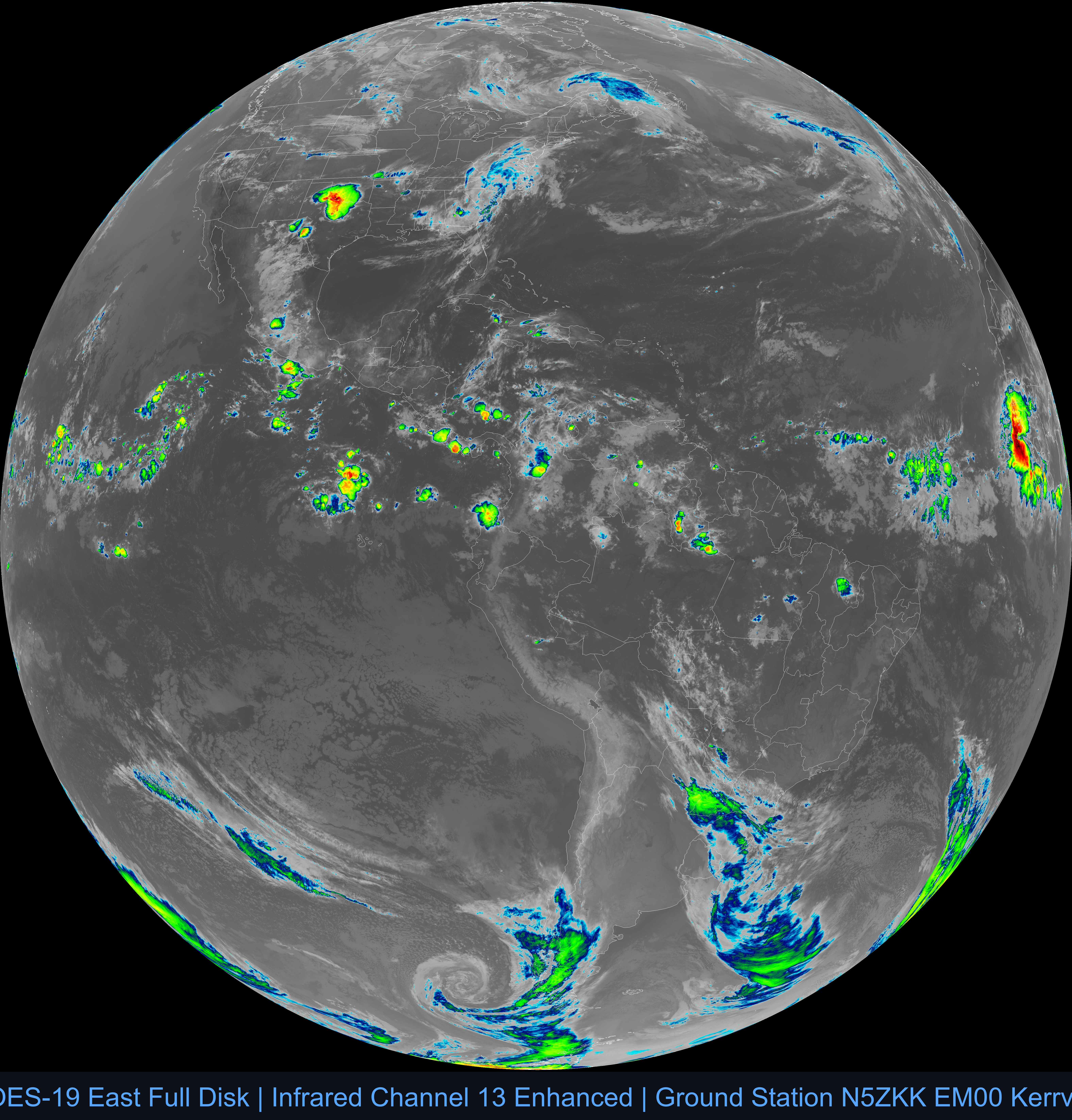
GOES-18 (West) Full Disk